
Topografische Karte L'Enfer
Interaktive Karte
Klicken Sie auf die Karte, um die Höhe anzuzeigen.
Über diese Karte
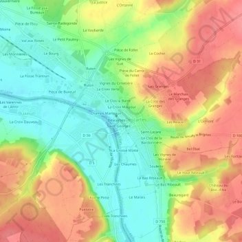
Name: Topografische Karte L'Enfer, Höhe, Relief.
Durchschnittliche Höhe: 78 m
Minimale Höhe: 41 m
Maximale Höhe: 115 m
Andere topografische Karten
Klicken Sie auf eine Karte, um ihre Topografie, ihre Höhe und ihr Relief anzuzeigen.
Le Moulin Neuf
France > Centre-Val de Loire > Indre-et-Loire > Descartes
Le Moulin Neuf, Descartes, Loches, Indre-et-Loire, Centre-Val de Loire, France métropolitaine, 37160, France
Durchschnittliche Höhe: 59 m
Les Vignes de Molière
France > Centre-Val de Loire > Indre-et-Loire > Descartes
Les Vignes de Molière, Descartes, Loches, Indre-et-Loire, Centre-Val de Loire, France métropolitaine, 37160, France
Durchschnittliche Höhe: 83 m
La Gare
France > Centre-Val de Loire > Indre-et-Loire > Descartes
La Gare, Descartes, Loches, Indre-et-Loire, Centre-Val de Loire, France métropolitaine, 37160, France
Durchschnittliche Höhe: 77 m