
Topografische Karte Municipal Unit of Sikyona
Interaktive Karte
Klicken Sie auf die Karte, um die Höhe anzuzeigen.
Über diese Karte
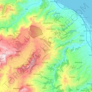
Name: Topografische Karte Municipal Unit of Sikyona, Höhe, Relief.
Durchschnittliche Höhe: 478 m
Minimale Höhe: 0 m
Maximale Höhe: 1.334 m
Andere topografische Karten
Klicken Sie auf eine Karte, um ihre Topografie, ihre Höhe und ihr Relief anzuzeigen.
Municipal Unit of Vocha
Greece > Peloponnese, Western Greece and the Ionian > Corinthia Regional Unit
Municipal Unit of Vocha, Municipality of Velo and Vocha, Corinthia Regional Unit, Peloponnese Region, Peloponnese, Western Greece and the Ionian, Greece
Durchschnittliche Höhe: 203 m
Corinth
Greece > Peloponnese, Western Greece and the Ionian > Corinthia Regional Unit
Corinth, Municipal Unit of Corinth, Municipality of Corinth, Corinthia Regional Unit, Peloponnese Region, Peloponnese, Western Greece and the Ionian, 201 00, Greece
Durchschnittliche Höhe: 185 m