
Topografische Karte Punalur
Interaktive Karte
Klicken Sie auf die Karte, um die Höhe anzuzeigen.
Über diese Karte
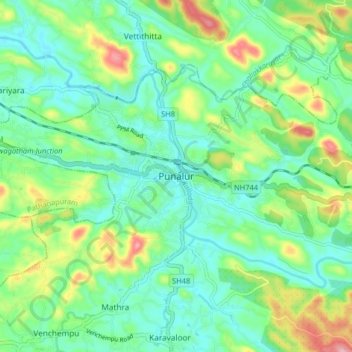
Name: Topografische Karte Punalur, Höhe, Relief.
Ort: Punalur, Kollam District, Kerala, 691305, India (8.97746 76.88648 9.05746 76.96648)
Durchschnittliche Höhe: 63 m
Minimale Höhe: 13 m
Maximale Höhe: 182 m
Punalur has an average elevation of 56 metres (184 ft). Many tourists have visited scenic spots along the Kallada River. The Palaruvi Falls is 35 kilometres (22 mi) from Punalur. The first planned eco-tourism project in Kerala is only 20 kilometres (12 mi) from Punalur on NH 744 towards Sengottai.
Andere topografische Karten
Klicken Sie auf eine Karte, um ihre Topografie, ihre Höhe und ihr Relief anzuzeigen.
Achankovil
Achankovil, Punalur, Kollam District, Kerala, India
Durchschnittliche Höhe: 177 m
Kulathupuzha
Kulathupuzha, Punalur, Kollam District, Kerala, 691310, India
Durchschnittliche Höhe: 150 m
Thenmala Dam
India > Kerala > Punalur > Thenmala
Thenmala Dam, Thenmala, Punalur, Kollam, Kerala, India
Durchschnittliche Höhe: 155 m
Vellor Ela Thodu
Vellor Ela Thodu, Punalur, Kollam, Kerala, 691548, India
Durchschnittliche Höhe: 77 m
Kulathupuzha
Kulathupuzha, Punalur, Kollam, Kerala, 691310, India
Durchschnittliche Höhe: 226 m
Shendurney WLS
India > Kerala > Punalur > Thenmala
Shendurney WLS, Thenmala, Punalur, Kollam, Kerala, India
Durchschnittliche Höhe: 367 m