
Topografische Karte Greenville
Interaktive Karte
Klicken Sie auf die Karte, um die Höhe anzuzeigen.
Über diese Karte
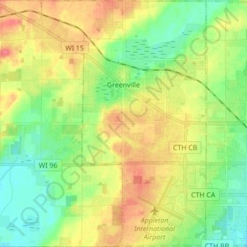
Name: Topografische Karte Greenville, Höhe, Relief.
Durchschnittliche Höhe: 258 m
Minimale Höhe: 232 m
Maximale Höhe: 292 m
Andere topografische Karten
Klicken Sie auf eine Karte, um ihre Topografie, ihre Höhe und ihr Relief anzuzeigen.
Appleton
United States > Wisconsin > Outagamie County
Appleton, Outagamie County, Wisconsin, United States
Durchschnittliche Höhe: 240 m
Town of Seymour
United States > Wisconsin > Outagamie County
Town of Seymour, Outagamie County, Wisconsin, United States
Durchschnittliche Höhe: 252 m
Little Chute
United States > Wisconsin > Outagamie County
Little Chute, Outagamie County, Wisconsin, 54140, United States
Durchschnittliche Höhe: 221 m
Seymour
United States > Wisconsin > Outagamie County
Seymour, Outagamie County, Wisconsin, 54165, United States
Durchschnittliche Höhe: 247 m
Black Creek
United States > Wisconsin > Outagamie County
Black Creek, Outagamie County, Wisconsin, 54106, United States
Durchschnittliche Höhe: 242 m
Kaukauna
United States > Wisconsin > Outagamie County
Kaukauna, Outagamie County, Wisconsin, 54130, United States
Durchschnittliche Höhe: 216 m
Freedom
United States > Wisconsin > Outagamie County
Freedom, Town of Freedom, Outagamie County, Wisconsin, United States
Durchschnittliche Höhe: 226 m
Bear Creek
United States > Wisconsin > Outagamie County
Bear Creek, Outagamie County, Wisconsin, United States
Durchschnittliche Höhe: 247 m
Town of Grand Chute
United States > Wisconsin > Outagamie County
Town of Grand Chute, Outagamie County, Wisconsin, United States
Durchschnittliche Höhe: 245 m
Hortonville
United States > Wisconsin > Outagamie County
Hortonville, Outagamie County, Wisconsin, United States
Durchschnittliche Höhe: 249 m
Kimberly
United States > Wisconsin > Outagamie County
Kimberly, Outagamie County, Wisconsin, 54136, United States
Durchschnittliche Höhe: 225 m