
Spenden
Rüsten Sie sich für Ihr nächstes Abenteuer:
Als Amazon-Partner erhält diese Website eine Provision für qualifizierte Käufe, ohne zusätzliche Kosten für Sie.
Topografische Karte Brymbo
Klicken Sie auf die Karte, um die Höhe anzuzeigen.
Spenden
Rüsten Sie sich für Ihr nächstes Abenteuer:
Als Amazon-Partner erhält diese Website eine Provision für qualifizierte Käufe, ohne zusätzliche Kosten für Sie.
Brymbo
While there was mining of coal in the area on a small scale, the late eighteenth century saw an expansion in activity, particularly after the industrialist John "Iron-Mad" Wilkinson purchased Brymbo Hall and began developing its estate, mining coal and ironstone and building an ironworks which was later to become the Brymbo Steelworks. By 1821 there was a total of 41 coal pits on the Brymbo Hall estate alone. In the nineteenth century, a number of larger deep mines were sunk around the area, and the majority of the village of Brymbo was developed as accommodation for the miners and ironworkers. The village itself was constructed on and around the steep sides of Brymbo Hill with views towards the Cheshire Plain, though the area's topography was later to cause problems when the steelworks expanded in 1956: the new parts had to be built on a vast artificial plateau of slag from the furnaces, filling the width of the valley and burying most of the village of Lodge, whose houses were purchased and demolished.
Spenden
Rüsten Sie sich für Ihr nächstes Abenteuer:
Als Amazon-Partner erhält diese Website eine Provision für qualifizierte Käufe, ohne zusätzliche Kosten für Sie.
Über diese Karte
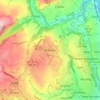
Name: Topografische Karte Brymbo, Höhe, Relief.
Ort: Brymbo, Wrexham, Wales, LL11 5AS, United Kingdom (53.05664 -3.08078 53.09664 -3.04078)
Durchschnittliche Höhe: 195 m
Minimale Höhe: 70 m
Maximale Höhe: 337 m
Spenden
Rüsten Sie sich für Ihr nächstes Abenteuer:
Als Amazon-Partner erhält diese Website eine Provision für qualifizierte Käufe, ohne zusätzliche Kosten für Sie.
Andere topografische Karten
Klicken Sie auf eine Karte, um ihre Topografie, ihre Höhe und ihr Relief anzuzeigen.
Spenden
Rüsten Sie sich für Ihr nächstes Abenteuer:
Als Amazon-Partner erhält diese Website eine Provision für qualifizierte Käufe, ohne zusätzliche Kosten für Sie.