
Topografische Karte Hinton
Interaktive Karte
Klicken Sie auf die Karte, um die Höhe anzuzeigen.
Über diese Karte
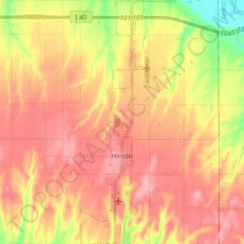
Name: Topografische Karte Hinton, Höhe, Relief.
Ort: Hinton, Caddo County, Oklahoma, United States (35.43482 -98.37679 35.53626 -98.34174)
Durchschnittliche Höhe: 482 m
Minimale Höhe: 416 m
Maximale Höhe: 523 m
Hinton is located in northeastern Caddo County at an elevation of 1,676 feet (511 m). The town limits extend north from the settled part of town 4 miles (6 km) along U.S. Route 281 to Interstate 40 at Exit 101, from which it is 49 miles (79 km) east to the center of Oklahoma City.
Andere topografische Karten
Klicken Sie auf eine Karte, um ihre Topografie, ihre Höhe und ihr Relief anzuzeigen.
Bridgeport
United States > Oklahoma > Caddo County
Bridgeport, Caddo County, Oklahoma, United States
Durchschnittliche Höhe: 444 m
Boone
United States > Oklahoma > Caddo County
Boone, Caddo County, Oklahoma, United States
Durchschnittliche Höhe: 426 m
Apache
United States > Oklahoma > Caddo County
Apache, Caddo County, Oklahoma, United States
Durchschnittliche Höhe: 390 m
Carnegie
United States > Oklahoma > Caddo County
Carnegie, Caddo County, Oklahoma, 73015, United States
Durchschnittliche Höhe: 410 m
Scott
United States > Oklahoma > Caddo County
Scott, Caddo County, Oklahoma, United States
Durchschnittliche Höhe: 483 m
Anadarko
United States > Oklahoma > Caddo County
Anadarko, Caddo County, Oklahoma, 73005, United States
Durchschnittliche Höhe: 369 m
Washita
United States > Oklahoma > Caddo County > Washita
Washita, Caddo County, Oklahoma, United States
Durchschnittliche Höhe: 382 m