
Topografische Karte Bydgoszcz
Interaktive Karte
Klicken Sie auf die Karte, um die Höhe anzuzeigen.
Über diese Karte
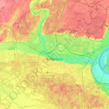
Name: Topografische Karte Bydgoszcz, Höhe, Relief.
Ort: Bydgoszcz, Kuyavian-Pomeranian Voivodeship, Poland (53.05011 17.87417 53.20934 18.20171)
Durchschnittliche Höhe: 71 m
Minimale Höhe: 26 m
Maximale Höhe: 113 m
The etymology of the German name of the town developed later and derives from the river Brahe (Brda in Polish), on whose banks the city is located, and berg, elevation, mount(ain), combined to 'Brahenberg', with 'a' pronounced in East Pomeranian Low German rather like 'å', later contracted to Bromberg, dropping the weak 'h', with the 'n' assimilated as 'm' to the following labial sound 'b'.
Andere topografische Karten
Klicken Sie auf eine Karte, um ihre Topografie, ihre Höhe und ihr Relief anzuzeigen.
Tatrzańskie
Poland > Kuyavian-Pomeranian Voivodeship > Bydgoszcz
Tatrzańskie, Bydgoszcz, Kuyavian-Pomeranian Voivodeship, Poland
Durchschnittliche Höhe: 71 m