
Topografische Karte La Forge D'Ans
Interaktive Karte
Klicken Sie auf die Karte, um die Höhe anzuzeigen.
Über diese Karte
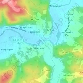
Name: Topografische Karte La Forge D'Ans, Höhe, Relief.
Durchschnittliche Höhe: 155 m
Minimale Höhe: 115 m
Maximale Höhe: 247 m
Andere topografische Karten
Klicken Sie auf eine Karte, um ihre Topografie, ihre Höhe und ihr Relief anzuzeigen.
Route Louise Michel
France > Nouvelle-Aquitaine > Cubjac-Auvézère-Val d'Ans > Le Château
Route Louise Michel, Le Château, Cubjac, Cubjac-Auvézère-Val d'Ans, Nontron, Dordogne, Nouvelle-Aquitaine, France métropolitaine, 24640, France
Durchschnittliche Höhe: 147 m
Villac
France > Nouvelle-Aquitaine > Cubjac-Auvézère-Val d'Ans
Villac, Cubjac, Cubjac-Auvézère-Val d'Ans, Nontron, Dordogne, Nouvelle-Aquitaine, France métropolitaine, 24640, France
Durchschnittliche Höhe: 151 m