
Topografische Karte Quantico
Interaktive Karte
Klicken Sie auf die Karte, um die Höhe anzuzeigen.
Über diese Karte
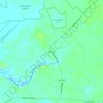
Name: Topografische Karte Quantico, Höhe, Relief.
Ort: Quantico, Wicomico County, Maryland, United States (38.35429 -75.76243 38.39429 -75.72243)
Durchschnittliche Höhe: 6 m
Minimale Höhe: -5 m
Maximale Höhe: 15 m
Andere topografische Karten
Klicken Sie auf eine Karte, um ihre Topografie, ihre Höhe und ihr Relief anzuzeigen.
Stellas Venture
United States > Maryland > Wicomico County
Stellas Venture, Wicomico County, Maryland, United States
Durchschnittliche Höhe: 19 m
Walston Switch
United States > Maryland > Wicomico County
Walston Switch, Wicomico County, Maryland, 21849, United States
Durchschnittliche Höhe: 18 m
Salisbury
United States > Maryland > Wicomico County > Salisbury
Salisbury, Wicomico County, Maryland, 21803, United States
Durchschnittliche Höhe: 11 m
Fruitland
United States > Maryland > Wicomico County
Fruitland, Wicomico County, Maryland, 21826, United States
Durchschnittliche Höhe: 11 m
Salisbury
United States > Maryland > Wicomico County
Salisbury, Wicomico County, Maryland, United States
Durchschnittliche Höhe: 12 m
Delmar
United States > Maryland > Wicomico County
Delmar, Wicomico County, Maryland, 19940, United States
Durchschnittliche Höhe: 15 m