
Topografische Karte Lake of the Woods
Interaktive Karte
Klicken Sie auf die Karte, um die Höhe anzuzeigen.
Über diese Karte
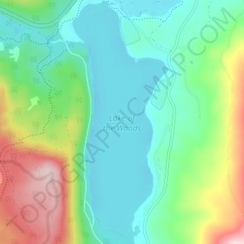
Name: Topografische Karte Lake of the Woods, Höhe, Relief.
Ort: Lake of the Woods, Klamath County, Oregon, United States (42.34352 -122.22695 42.38850 -122.20306)
Durchschnittliche Höhe: 1.588 m
Minimale Höhe: 1.501 m
Maximale Höhe: 1.798 m
Lake of the Woods is located near the crest of the Cascade Mountains in western Klamath County, Oregon. Its elevation is 4,949 feet (1,508 m) above sea level. The lake is surrounded by the Fremont–Winema National Forest. Lake of the Woods is 33 miles (53 km) west of Klamath Falls and 43 miles (69 km) east of Medford. The small unincorporated community of Lake of the Woods, Oregon, is located on the east shore of the lake, approximately 1⁄2 mile (0.80 km) south of Oregon Route 140. There is a Forest Service visitor center at the historic Lake of the Woods Ranger Station at the north end of the lake, just off Route 140. The visitor center is open during the summer.
Andere topografische Karten
Klicken Sie auf eine Karte, um ihre Topografie, ihre Höhe und ihr Relief anzuzeigen.
Klamath Falls
United States > Oregon > Klamath County
Klamath Falls, Klamath County, Oregon, 97601, United States
Durchschnittliche Höhe: 1.312 m
Dairy
United States > Oregon > Klamath County
Dairy, Klamath County, Oregon, 97625, United States
Durchschnittliche Höhe: 1.300 m
Crater Lake National Park
United States > Oregon > Klamath County
Crater Lake National Park, Klamath County, Oregon, 97604, United States
Durchschnittliche Höhe: 1.726 m
Rock Point
United States > Oregon > Klamath County
Rock Point, Klamath County, Oregon, 97731, United States
Durchschnittliche Höhe: 1.415 m
Altamont
United States > Oregon > Klamath County
Altamont, Klamath County, Oregon, 97603, United States
Durchschnittliche Höhe: 1.310 m
Chemult
United States > Oregon > Klamath County
Chemult, Klamath County, Oregon, United States
Durchschnittliche Höhe: 1.480 m
Crescent
United States > Oregon > Klamath County
Crescent, Klamath County, Oregon, United States
Durchschnittliche Höhe: 1.389 m
Sprague River
United States > Oregon > Klamath County
Sprague River, Klamath County, Oregon, 97639, United States
Durchschnittliche Höhe: 1.472 m
Malin
United States > Oregon > Klamath County
Malin, Klamath County, Oregon, United States
Durchschnittliche Höhe: 1.241 m
Altamont
United States > Oregon > Klamath County > Altamont
Altamont, Klamath County, Oregon, 97603, United States
Durchschnittliche Höhe: 1.285 m
Merrill
United States > Oregon > Klamath County
Merrill, Klamath County, Oregon, United States
Durchschnittliche Höhe: 1.241 m
Mount Scott
United States > Oregon > Klamath County
Mount Scott, Klamath County, Oregon, United States
Durchschnittliche Höhe: 2.295 m
Fort Klamath
United States > Oregon > Klamath County
Fort Klamath, Klamath County, Oregon, United States
Durchschnittliche Höhe: 1.273 m
Chiloquin
United States > Oregon > Klamath County
Chiloquin, Klamath County, Oregon, United States
Durchschnittliche Höhe: 1.302 m
Beatty
United States > Oregon > Klamath County
Beatty, Klamath County, Oregon, 97602, United States
Durchschnittliche Höhe: 1.330 m
Odell Lake
United States > Oregon > Klamath County > Odell Lake
Odell Lake, Klamath County, Oregon, United States
Durchschnittliche Höhe: 1.492 m
Crater Lake
United States > Oregon > Klamath County
Crater Lake, Klamath County, Oregon, United States
Durchschnittliche Höhe: 1.971 m
Bonanza
United States > Oregon > Klamath County
Bonanza, Klamath County, Oregon, United States
Durchschnittliche Höhe: 1.263 m
Keno
United States > Oregon > Klamath County
Keno, Klamath County, Oregon, 97627, United States
Durchschnittliche Höhe: 1.287 m
Mount Mazama
United States > Oregon > Klamath County
Mount Mazama, Klamath County, Oregon, United States
Durchschnittliche Höhe: 1.880 m