
Spenden
Rüsten Sie sich für Ihr nächstes Abenteuer:
Als Amazon-Partner erhält diese Website eine Provision für qualifizierte Käufe, ohne zusätzliche Kosten für Sie.
Topografische Karte Glenfield
Klicken Sie auf die Karte, um die Höhe anzuzeigen.
Spenden
Rüsten Sie sich für Ihr nächstes Abenteuer:
Als Amazon-Partner erhält diese Website eine Provision für qualifizierte Käufe, ohne zusätzliche Kosten für Sie.
Über diese Karte
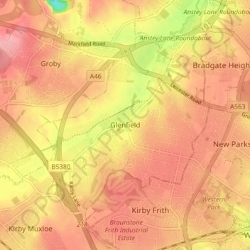
Name: Topografische Karte Glenfield, Höhe, Relief.
Durchschnittliche Höhe: 88 m
Minimale Höhe: 18 m
Maximale Höhe: 120 m
Spenden
Rüsten Sie sich für Ihr nächstes Abenteuer:
Als Amazon-Partner erhält diese Website eine Provision für qualifizierte Käufe, ohne zusätzliche Kosten für Sie.
Andere topografische Karten
Klicken Sie auf eine Karte, um ihre Topografie, ihre Höhe und ihr Relief anzuzeigen.
Stoke Golding
United Kingdom > England > Leicestershire > Hinckley and Bosworth
Durchschnittliche Höhe: 102 m
Spenden
Rüsten Sie sich für Ihr nächstes Abenteuer:
Als Amazon-Partner erhält diese Website eine Provision für qualifizierte Käufe, ohne zusätzliche Kosten für Sie.
Kelham Bridge Nature Reserve
United Kingdom > England > Leicestershire > North West Leicestershire > Ravenstone
Durchschnittliche Höhe: 139 m
Market Bosworth Country Park
United Kingdom > England > Leicestershire > Hinckley and Bosworth > Market Bosworth
Durchschnittliche Höhe: 119 m
Watermead Country Park
United Kingdom > England > Leicestershire > Charnwood > Birstall
Durchschnittliche Höhe: 59 m
Spenden
Rüsten Sie sich für Ihr nächstes Abenteuer:
Als Amazon-Partner erhält diese Website eine Provision für qualifizierte Käufe, ohne zusätzliche Kosten für Sie.
Markfield
United Kingdom > England > Leicestershire > Hinckley and Bosworth > Markfield
Durchschnittliche Höhe: 174 m
Castle Donington
United Kingdom > England > Leicestershire > North West Leicestershire > Hemington
Durchschnittliche Höhe: 56 m
Kibworth Beauchamp
United Kingdom > England > Leicestershire > Harborough
Durchschnittliche Höhe: 113 m
Bottesford
United Kingdom > England > Leicestershire > Melton
Bottesford's many listed buildings include the grade I listed 13th-century Church of St Mary the Virgin. There are two scheduled monuments within the village – Fleming's Bridge and the stone cross in the Market Place. The stocks and whipping post are Grade II listed. One of the Grade II listed buildings,…
Durchschnittliche Höhe: 39 m
Spenden
Rüsten Sie sich für Ihr nächstes Abenteuer:
Als Amazon-Partner erhält diese Website eine Provision für qualifizierte Käufe, ohne zusätzliche Kosten für Sie.
South Croxton
United Kingdom > England > Leicestershire > Charnwood > South Croxton
The highest point is the church, at 120 m above mean sea level. The lowest altitude is 85 m by the Queniborough Brook.
Durchschnittliche Höhe: 108 m
Spenden
Rüsten Sie sich für Ihr nächstes Abenteuer:
Als Amazon-Partner erhält diese Website eine Provision für qualifizierte Käufe, ohne zusätzliche Kosten für Sie.
Brocks Hill
United Kingdom > England > Leicestershire > Oadby and Wigston > Oadby
Durchschnittliche Höhe: 102 m
Groby
United Kingdom > England > Leicestershire > Hinckley and Bosworth > Groby
Durchschnittliche Höhe: 107 m
Adrian's Spinney
United Kingdom > England > Leicestershire > Harborough > Stoughton
Durchschnittliche Höhe: 113 m
Swannington
United Kingdom > England > Leicestershire > North West Leicestershire > Coalville
Durchschnittliche Höhe: 132 m
Spenden
Rüsten Sie sich für Ihr nächstes Abenteuer:
Als Amazon-Partner erhält diese Website eine Provision für qualifizierte Käufe, ohne zusätzliche Kosten für Sie.
Stoughton
United Kingdom > England > Leicestershire > Harborough > Stoughton
Durchschnittliche Höhe: 122 m
Ashby-de-la-Zouch
United Kingdom > England > Leicestershire > North West Leicestershire
Durchschnittliche Höhe: 132 m
Queniborough
United Kingdom > England > Leicestershire > Charnwood > Queniborough
Durchschnittliche Höhe: 75 m
Spenden
Rüsten Sie sich für Ihr nächstes Abenteuer:
Als Amazon-Partner erhält diese Website eine Provision für qualifizierte Käufe, ohne zusätzliche Kosten für Sie.
Illston on the Hill
United Kingdom > England > Leicestershire > Harborough > Illston on the Hill
Durchschnittliche Höhe: 158 m
Spenden
Rüsten Sie sich für Ihr nächstes Abenteuer:
Als Amazon-Partner erhält diese Website eine Provision für qualifizierte Käufe, ohne zusätzliche Kosten für Sie.
Gilmorton
United Kingdom > England > Leicestershire > Harborough > Gilmorton
Durchschnittliche Höhe: 136 m
Langham Brook
United Kingdom > England > Leicestershire > Melton > Saxby > Freeby
Durchschnittliche Höhe: 94 m
Spenden
Rüsten Sie sich für Ihr nächstes Abenteuer:
Als Amazon-Partner erhält diese Website eine Provision für qualifizierte Käufe, ohne zusätzliche Kosten für Sie.
Great Glen
United Kingdom > England > Leicestershire > Harborough > Great Glen
Durchschnittliche Höhe: 115 m
Buckminster
United Kingdom > England > Leicestershire > Melton > Buckminster
Durchschnittliche Höhe: 135 m
Lount Wood
United Kingdom > England > Leicestershire > North West Leicestershire > Lount
Durchschnittliche Höhe: 131 m
Leicester Forest East
United Kingdom > England > Leicestershire > Leicester Forest East
Durchschnittliche Höhe: 96 m
Spenden
Rüsten Sie sich für Ihr nächstes Abenteuer:
Als Amazon-Partner erhält diese Website eine Provision für qualifizierte Käufe, ohne zusätzliche Kosten für Sie.
Slawston
United Kingdom > England > Leicestershire > Harborough > Slawston
Durchschnittliche Höhe: 94 m
South Kilworth
United Kingdom > England > Leicestershire > Harborough > South Kilworth
Durchschnittliche Höhe: 134 m
Leicestershire
United Kingdom > England > Leicestershire
A large part of the north-west of the county, around Coalville, forms part of the new National Forest area extending into Derbyshire and Staffordshire. The highest point of the county is Bardon Hill at 278 m (912 ft), which is also a Marilyn; with other hilly/upland areas of c. 150–200 metres (490–660 ft)…
Durchschnittliche Höhe: 98 m
Spenden
Rüsten Sie sich für Ihr nächstes Abenteuer:
Als Amazon-Partner erhält diese Website eine Provision für qualifizierte Käufe, ohne zusätzliche Kosten für Sie.
Ibstock
United Kingdom > England > Leicestershire > North West Leicestershire
Durchschnittliche Höhe: 134 m
Whitwick
United Kingdom > England > Leicestershire > North West Leicestershire
Durchschnittliche Höhe: 152 m
Bradgate Park
United Kingdom > England > Leicestershire > Charnwood > Newtown Linford
Overlying the Beacon Hill Formation, but found a little further down the hillside to the south, are the Bradgate Formation beds, the most notable of which is the Sliding Stone Slump Breccia rocks. Forming a line of crags below Old John, these are laminated mudstones, with layers of sandstone, mainly of…
Durchschnittliche Höhe: 126 m
Shepshed
United Kingdom > England > Leicestershire > Charnwood > Shepshed
Durchschnittliche Höhe: 111 m
Spenden
Rüsten Sie sich für Ihr nächstes Abenteuer:
Als Amazon-Partner erhält diese Website eine Provision für qualifizierte Käufe, ohne zusätzliche Kosten für Sie.
Broughton Astley
United Kingdom > England > Leicestershire > Harborough > Broughton Astley
Durchschnittliche Höhe: 87 m
Nailstone Colliery Railway
United Kingdom > England > Leicestershire > North West Leicestershire > Ibstock
Durchschnittliche Höhe: 155 m
Breedon Cloud Wood
United Kingdom > England > Leicestershire > North West Leicestershire > Breedon on the Hill
Durchschnittliche Höhe: 90 m
Spenden
Rüsten Sie sich für Ihr nächstes Abenteuer:
Als Amazon-Partner erhält diese Website eine Provision für qualifizierte Käufe, ohne zusätzliche Kosten für Sie.
Mountsorrel
United Kingdom > England > Leicestershire > Charnwood > Mountsorrel
Durchschnittliche Höhe: 57 m
Swannymote Rock
United Kingdom > England > Leicestershire > North West Leicestershire > Coalville
Durchschnittliche Höhe: 139 m
Thornton Reservoir
United Kingdom > England > Leicestershire > Hinckley and Bosworth > Thornton
Durchschnittliche Höhe: 139 m
Spenden
Rüsten Sie sich für Ihr nächstes Abenteuer:
Als Amazon-Partner erhält diese Website eine Provision für qualifizierte Käufe, ohne zusätzliche Kosten für Sie.
Willesley Woods
United Kingdom > England > Leicestershire > North West Leicestershire > Ashby-de-la-Zouch > Willesley
Durchschnittliche Höhe: 108 m
Earl Shilton
United Kingdom > England > Leicestershire > Hinckley and Bosworth
Durchschnittliche Höhe: 101 m
Moat Hill Spinney
United Kingdom > England > Leicestershire > Charnwood > Cotes
Durchschnittliche Höhe: 50 m
Belvoir Castle
United Kingdom > England > Leicestershire > Melton > Belvoir
The traditional burial place of the Manners family was St Mary the Virgin's Church, Bottesford. Since elevation to the dukedom in 1703 most Dukes have been buried in the grounds of the mausoleum at Belvoir Castle. The mausoleum at Belvoir Castle was built by The 5th Duke of Rutland, following the death of his…
Durchschnittliche Höhe: 82 m
Spenden
Rüsten Sie sich für Ihr nächstes Abenteuer:
Als Amazon-Partner erhält diese Website eine Provision für qualifizierte Käufe, ohne zusätzliche Kosten für Sie.
Lea Wood
United Kingdom > England > Leicestershire > Charnwood > Newtown Linford
Durchschnittliche Höhe: 170 m
Spenden
Rüsten Sie sich für Ihr nächstes Abenteuer:
Als Amazon-Partner erhält diese Website eine Provision für qualifizierte Käufe, ohne zusätzliche Kosten für Sie.
Charnwood Water
United Kingdom > England > Leicestershire > Charnwood > Woodthorpe
Durchschnittliche Höhe: 47 m
Osgathorpe
United Kingdom > England > Leicestershire > North West Leicestershire
Durchschnittliche Höhe: 96 m
Spenden
Rüsten Sie sich für Ihr nächstes Abenteuer:
Als Amazon-Partner erhält diese Website eine Provision für qualifizierte Käufe, ohne zusätzliche Kosten für Sie.
Thurmaston
United Kingdom > England > Leicestershire > Charnwood > Thurmaston
Durchschnittliche Höhe: 62 m
Normanton Le Heath
United Kingdom > England > Leicestershire > North West Leicestershire
Durchschnittliche Höhe: 123 m
Spenden
Rüsten Sie sich für Ihr nächstes Abenteuer:
Als Amazon-Partner erhält diese Website eine Provision für qualifizierte Käufe, ohne zusätzliche Kosten für Sie.
Spenden
Rüsten Sie sich für Ihr nächstes Abenteuer:
Als Amazon-Partner erhält diese Website eine Provision für qualifizierte Käufe, ohne zusätzliche Kosten für Sie.
Croxton Kerrial
United Kingdom > England > Leicestershire > Melton > Croxton Kerrial
Durchschnittliche Höhe: 128 m
Spenden
Rüsten Sie sich für Ihr nächstes Abenteuer:
Als Amazon-Partner erhält diese Website eine Provision für qualifizierte Käufe, ohne zusätzliche Kosten für Sie.
Carlton
United Kingdom > England > Leicestershire > Hinckley and Bosworth
Durchschnittliche Höhe: 102 m
Kegworth
United Kingdom > England > Leicestershire > North West Leicestershire > Kegworth
Durchschnittliche Höhe: 49 m
Kimcote and Walton
United Kingdom > England > Leicestershire > Harborough > Kimcote and Walton
Durchschnittliche Höhe: 144 m
Spenden
Rüsten Sie sich für Ihr nächstes Abenteuer:
Als Amazon-Partner erhält diese Website eine Provision für qualifizierte Käufe, ohne zusätzliche Kosten für Sie.
Saddington
United Kingdom > England > Leicestershire > Harborough > Saddington
Durchschnittliche Höhe: 127 m
Packington
United Kingdom > England > Leicestershire > North West Leicestershire
Durchschnittliche Höhe: 119 m
Spenden
Rüsten Sie sich für Ihr nächstes Abenteuer:
Als Amazon-Partner erhält diese Website eine Provision für qualifizierte Käufe, ohne zusätzliche Kosten für Sie.
Ratcliffe on the Wreake
United Kingdom > England > Leicestershire > Charnwood
Durchschnittliche Höhe: 69 m
Shearsby
United Kingdom > England > Leicestershire > Harborough > Shearsby
Durchschnittliche Höhe: 131 m
Little Stretton
United Kingdom > England > Leicestershire > Harborough > Little Stretton
Durchschnittliche Höhe: 132 m
Spenden
Rüsten Sie sich für Ihr nächstes Abenteuer:
Als Amazon-Partner erhält diese Website eine Provision für qualifizierte Käufe, ohne zusätzliche Kosten für Sie.
Cadeby
United Kingdom > England > Leicestershire > Hinckley and Bosworth
Durchschnittliche Höhe: 123 m
Spenden
Rüsten Sie sich für Ihr nächstes Abenteuer:
Als Amazon-Partner erhält diese Website eine Provision für qualifizierte Käufe, ohne zusätzliche Kosten für Sie.
Spenden
Rüsten Sie sich für Ihr nächstes Abenteuer:
Als Amazon-Partner erhält diese Website eine Provision für qualifizierte Käufe, ohne zusätzliche Kosten für Sie.
Burton on the Wolds
United Kingdom > England > Leicestershire > Charnwood
Durchschnittliche Höhe: 78 m
Coleorton
United Kingdom > England > Leicestershire > North West Leicestershire
Durchschnittliche Höhe: 130 m
Spenden
Rüsten Sie sich für Ihr nächstes Abenteuer:
Als Amazon-Partner erhält diese Website eine Provision für qualifizierte Käufe, ohne zusätzliche Kosten für Sie.