
Topografische Karte Mount Russell
Interaktive Karte
Klicken Sie auf die Karte, um die Höhe anzuzeigen.
Über diese Karte
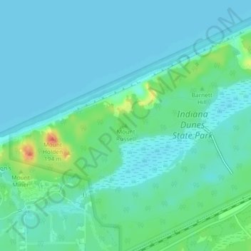
Name: Topografische Karte Mount Russell, Höhe, Relief.
Ort: Mount Russell, Porter County, Indiana, USA (41.66572 -87.04241 41.66582 -87.04231)
Durchschnittliche Höhe: 184 m
Minimale Höhe: 175 m
Maximale Höhe: 218 m
Andere topografische Karten
Klicken Sie auf eine Karte, um ihre Topografie, ihre Höhe und ihr Relief anzuzeigen.
Little Cedar Lake
Little Cedar Lake, East Island Court, Tri-Lakes, Whitley County, Indiana, USA
Durchschnittliche Höhe: 284 m
Logansport
USA > Indiana > Logansport
Logansport, Cass County, Indiana, 46947, USA
Durchschnittliche Höhe: 203 m
Maple Lane
USA > Indiana > Maple Lane
Maple Lane, Saint Joseph County, Indiana, 46617:46635, USA
Durchschnittliche Höhe: 229 m
Eaglewood Estates
USA > Indiana > Eaglewood Estates
Eaglewood Estates, Boone County, Indiana, 46077, USA
Durchschnittliche Höhe: 279 m
Bloomfield
USA > Indiana > Bloomfield
Bloomfield, Greene County, Indiana, 47424, USA
Durchschnittliche Höhe: 168 m
Preservation Park
USA > Indiana > Jeffersonville
Preservation Park, 120, Jeffersonville, Clark County, Indiana, 47130, USA
Durchschnittliche Höhe: 136 m
Ontario Park
Ontario Park, Ontario, LaGrange County, Indiana, USA
Durchschnittliche Höhe: 269 m
Cherryvale
USA > Indiana > Cherryvale
Cherryvale, Vigo County, Indiana, 47878, USA
Durchschnittliche Höhe: 186 m
Anderson River
Anderson River, Spencer County, Indiana, 47588, USA
Durchschnittliche Höhe: 139 m
Clarksville
USA > Indiana > Clarksville
Clarksville, Clark County, Indiana, 47129, USA
Durchschnittliche Höhe: 150 m
Holmesville
USA > Indiana > Holmesville
Holmesville, LaPorte County, Indiana, 46391, USA
Durchschnittliche Höhe: 240 m