
Topografische Karte Eisacktal - Valle Isarco
Interaktive Karte
Klicken Sie auf die Karte, um die Höhe anzuzeigen.
Über diese Karte
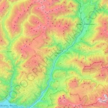
Name: Topografische Karte Eisacktal - Valle Isarco, Höhe, Relief.
Durchschnittliche Höhe: 1.487 m
Minimale Höhe: 250 m
Maximale Höhe: 3.179 m
Andere topografische Karten
Klicken Sie auf eine Karte, um ihre Topografie, ihre Höhe und ihr Relief anzuzeigen.
Stilfs - Stelvio
Italy > Trentino-Alto Adige/Südtirol > South Tyrol
Stilfs - Stelvio, Vinschgau - Val Venosta, South Tyrol, Trentino-Alto Adige/Südtirol, 39029, Italy
Durchschnittliche Höhe: 2.419 m
Etsch - Adige
Italy > Trentino-Alto Adige/Südtirol > South Tyrol > Tarnell - Tarnello > Oberplatz
Etsch - Adige, Oberplatz, Tarnell - Tarnello, Laas - Lasa, Vinschgau - Val Venosta, South Tyrol, Trentino-Alto Adige/Südtirol, 39023, Italy
Durchschnittliche Höhe: 1.075 m
Sëlva - Wolkenstein - Selva
Italy > Trentino-Alto Adige/Südtirol > South Tyrol > Sëlva - Wolkenstein - Selva di Val Gardena
Sëlva - Wolkenstein - Selva, Sëlva - Wolkenstein - Selva di Val Gardena, Salten-Schlern - Salto-Sciliar, South Tyrol, Trentino-Alto Adige/Südtirol, 39048, Italy
Durchschnittliche Höhe: 1.828 m
Pens - Pennes
Italy > Trentino-Alto Adige/Südtirol > South Tyrol > Sarntal - Sarentino
Pens - Pennes, Sarntal - Sarentino, Salten-Schlern - Salto-Sciliar, South Tyrol, Trentino-Alto Adige/Südtirol, Italy
Durchschnittliche Höhe: 1.850 m
Viums - Fiumes
Italy > Trentino-Alto Adige/Südtirol > South Tyrol > Natz-Schabs - Naz-Sciaves
Viums - Fiumes, Natz-Schabs - Naz-Sciaves, Eisacktal - Valle Isarco, South Tyrol, Trentino-Alto Adige/Südtirol, 39037, Italy
Durchschnittliche Höhe: 847 m
Neustift - Novacella
Italy > Trentino-Alto Adige/Südtirol > South Tyrol
Neustift - Novacella, Vahrn - Varna, Eisacktal - Valle Isarco, South Tyrol, Trentino-Alto Adige/Südtirol, 39042, Italy
Durchschnittliche Höhe: 777 m
Pfitsch - Val di Vizze
Italy > Trentino-Alto Adige/Südtirol > South Tyrol
Pfitsch - Val di Vizze, Wipptal - Alta Vall'Isarco, South Tyrol, Trentino-Alto Adige/Südtirol, 39049, Italy
Durchschnittliche Höhe: 1.953 m
Fleins - Lines
Italy > Trentino-Alto Adige/Südtirol > South Tyrol > Freienfeld - Campo di Trens > Mauls - Mules
Fleins - Lines, Mauls - Mules, Freienfeld - Campo di Trens, Wipptal - Alta Vall'Isarco, South Tyrol, Trentino-Alto Adige/Südtirol, Italy
Durchschnittliche Höhe: 1.367 m
Franzensfeste - Fortezza
Italy > Trentino-Alto Adige/Südtirol > South Tyrol > Franzensfeste - Fortezza
Franzensfeste - Fortezza, Wipptal - Alta Vall'Isarco, South Tyrol, Trentino-Alto Adige/Südtirol, 39045, Italy
Durchschnittliche Höhe: 1.417 m
Klettergarten Hohe Festung (Franzenfeste)
Italy > Trentino-Alto Adige/Südtirol > South Tyrol > Franzensfeste - Fortezza > Obersalcher
Klettergarten Hohe Festung (Franzenfeste), Obersalcher, Franzensfeste - Fortezza, Wipptal - Alta Vall'Isarco, South Tyrol, Trentino-Alto Adige/Südtirol, 39045, Italy
Durchschnittliche Höhe: 1.048 m
Innichen - San Candido
Italy > Trentino-Alto Adige/Südtirol > South Tyrol
Innichen - San Candido, Pustertal - Val Pusteria, South Tyrol, Trentino-Alto Adige/Südtirol, Italy
Durchschnittliche Höhe: 1.791 m
Meran - Merano
Italy > Trentino-Alto Adige/Südtirol > South Tyrol
Meran - Merano, Burggrafenamt - Burgraviato, South Tyrol, Trentino-Alto Adige/Südtirol, 39012, Italy
Durchschnittliche Höhe: 635 m
Moos in Passeier - Moso in Passiria
Italy > Trentino-Alto Adige/Südtirol > South Tyrol
Moos in Passeier - Moso in Passiria, Burggrafenamt - Burgraviato, South Tyrol, Trentino-Alto Adige/Südtirol, 39013, Italy
Durchschnittliche Höhe: 2.082 m
Bolzano - Bozen
Italy > Trentino-Alto Adige/Südtirol > South Tyrol
Bolzano - Bozen, South Tyrol, Trentino-Alto Adige/Südtirol, 39100, Italy
Durchschnittliche Höhe: 675 m