
Topografische Karte Paravur
Interaktive Karte
Klicken Sie auf die Karte, um die Höhe anzuzeigen.
Über diese Karte
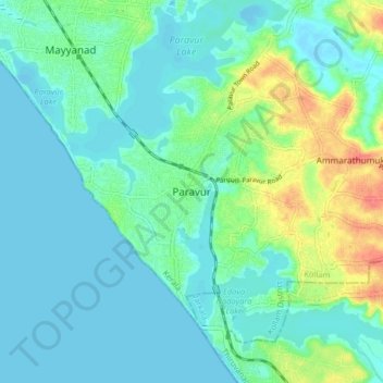
Name: Topografische Karte Paravur, Höhe, Relief.
Ort: Paravur, Kollam, Kollam District, Kerala, 691301, India (8.76989 76.63153 8.84989 76.71153)
Durchschnittliche Höhe: 14 m
Minimale Höhe: -5 m
Maximale Höhe: 60 m
Paravur is located at 8.78 N 76 E. It has an average elevation of 10 metres (32 feet). Paravur, 21 kilometers from the Kollam, is a narrow skirt of land stretching in between the backwaters and the sea. There is an elevation of 6 metres above sea level, extending to 16 metres on the inland. Ithikkara river is flowing through paravur. Nedungolam in paravur is now famous for mangrove forest.
Andere topografische Karten
Klicken Sie auf eine Karte, um ihre Topografie, ihre Höhe und ihr Relief anzuzeigen.
Kizhakkekallada
Kizhakkekallada, Kollam, Kollam District, Kerala, 691502, India
Durchschnittliche Höhe: 10 m
Chirakkara
Chirakkara, Kollam, Kollam District, Kerala, 691578, India
Durchschnittliche Höhe: 36 m
Thrikkovilvattom
India > Kerala > Kollam > Thrikkovilvattom
Thrikkovilvattom, Kollam, Kerala, 691577, India
Durchschnittliche Höhe: 23 m