
Topografische Karte Mendenhall Springs
Klicken Sie auf die Karte, um die Höhe anzuzeigen.
Über diese Karte
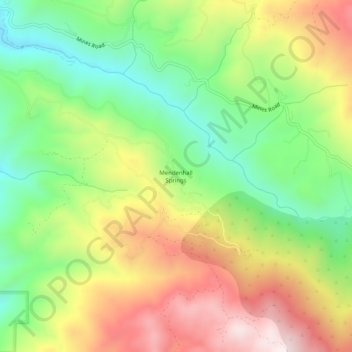
Name: Topografische Karte Mendenhall Springs, Höhe, Relief.
Durchschnittliche Höhe: 609 m
Minimale Höhe: 302 m
Maximale Höhe: 994 m
Andere topografische Karten
Klicken Sie auf eine Karte, um ihre Topografie, ihre Höhe und ihr Relief anzuzeigen.
Garin Regional Park
United States > California > Alameda County > Hayward
Durchschnittliche Höhe: 206 m
Horseshoe Lake
United States > California > Alameda County > Fremont > Eberly
Durchschnittliche Höhe: 23 m
Quarry Lakes Regional Park
United States > California > Alameda County > Fremont > Eberly
Durchschnittliche Höhe: 17 m
John F Kennedy Park
United States > California > Alameda County > Hayward
Durchschnittliche Höhe: 11 m
Oakland Casting Club pools
United States > California > Alameda County > Oakland
Durchschnittliche Höhe: 158 m
Dougherty Hills Open Space
United States > California > Alameda County > Dublin > Komandorski Village
Durchschnittliche Höhe: 120 m
Reinhardt-Redwood Regional Park
United States > California > Alameda County > Oakland
Durchschnittliche Höhe: 292 m
Lake Del Valle
United States > California > Alameda County
The dam is 230 feet (70 m) high and 880 feet (270 m) long. Its crest elevation is 773 feet (236 m). The dam contains 4,150,000 cubic yards (3,170,000 m3) of earth fill.
Durchschnittliche Höhe: 339 m