
Topografische Karte Decatur
Interaktive Karte
Klicken Sie auf die Karte, um die Höhe anzuzeigen.
Über diese Karte
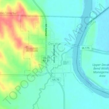
Name: Topografische Karte Decatur, Höhe, Relief.
Ort: Decatur, Burt County, Nebraska, United States (41.99525 -96.26120 42.01438 -96.23684)
Durchschnittliche Höhe: 335 m
Minimale Höhe: 314 m
Maximale Höhe: 391 m
Andere topografische Karten
Klicken Sie auf eine Karte, um ihre Topografie, ihre Höhe und ihr Relief anzuzeigen.
Tekamah
United States > Nebraska > Burt County
Tekamah, Burt County, Nebraska, United States
Durchschnittliche Höhe: 329 m
Lyons
United States > Nebraska > Burt County
Lyons, Burt County, Nebraska, United States
Durchschnittliche Höhe: 394 m
Oakland
United States > Nebraska > Burt County
Oakland, Burt County, Nebraska, United States
Durchschnittliche Höhe: 395 m
Craig
United States > Nebraska > Burt County
Craig, Burt County, Nebraska, United States
Durchschnittliche Höhe: 398 m