
Topografische Karte Indian Springs
Interaktive Karte
Klicken Sie auf die Karte, um die Höhe anzuzeigen.
Über diese Karte
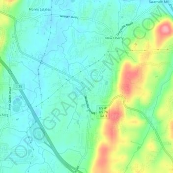
Name: Topografische Karte Indian Springs, Höhe, Relief.
Ort: Indian Springs, Catoosa County, Georgia, United States (34.94135 -85.18172 34.97698 -85.13672)
Durchschnittliche Höhe: 236 m
Minimale Höhe: 204 m
Maximale Höhe: 319 m
Andere topografische Karten
Klicken Sie auf eine Karte, um ihre Topografie, ihre Höhe und ihr Relief anzuzeigen.
Boynton
United States > Georgia > Catoosa County
Boynton, Catoosa County, Georgia, 30736, United States
Durchschnittliche Höhe: 239 m
Lakeview
United States > Georgia > Catoosa County > Fort Oglethorpe
Lakeview, Fort Oglethorpe, Catoosa County, Georgia, United States
Durchschnittliche Höhe: 237 m
Ringgold
United States > Georgia > Catoosa County
Ringgold, Catoosa County, Georgia, United States
Durchschnittliche Höhe: 268 m
Blue Spring
United States > Georgia > Catoosa County
Blue Spring, Catoosa County, Georgia, United States, Blue Spring Lake
Durchschnittliche Höhe: 236 m
Cloud Springs
United States > Georgia > Catoosa County > Fort Oglethorpe
Cloud Springs, Fort Oglethorpe, Catoosa County, Georgia, 30742, United States
Durchschnittliche Höhe: 237 m
Fort Oglethorpe
United States > Georgia > Catoosa County
Fort Oglethorpe, Catoosa County, Georgia, 30742, United States
Durchschnittliche Höhe: 236 m