
Topografische Karte Jabal Saraj
Interaktive Karte
Klicken Sie auf die Karte, um die Höhe anzuzeigen.
Jabal Saraj
Jabal Saraj town has a Mediterranean climate (Köppen climate classification Csa) with hot, dry summers and cold, wet winters. Snow is not unusual in winter. Nearby areas may have a cold semi-arid climate (Köppen climate classification BSk) or a humid continental climate (Köppen climate classification Dsa/Dsb) depending on altitude and topography.
Über diese Karte
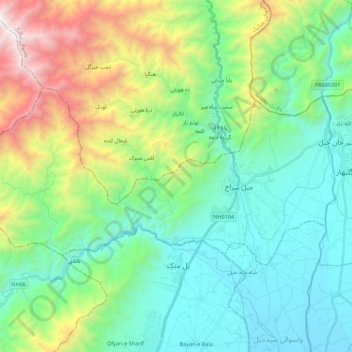
Name: Topografische Karte Jabal Saraj, Höhe, Relief.
Ort: Jabal Saraj, Parwan Province, Afghanistan (35.08176 69.07359 35.17218 69.29303)
Durchschnittliche Höhe: 2.082 m
Minimale Höhe: 1.471 m
Maximale Höhe: 3.758 m