
Topografische Karte Sensenruth
Interaktive Karte
Klicken Sie auf die Karte, um die Höhe anzuzeigen.
Über diese Karte
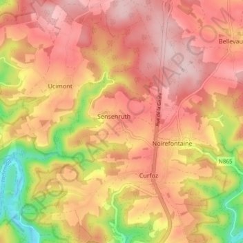
Name: Topografische Karte Sensenruth, Höhe, Relief.
Durchschnittliche Höhe: 358 m
Minimale Höhe: 203 m
Maximale Höhe: 447 m
Andere topografische Karten
Klicken Sie auf eine Karte, um ihre Topografie, ihre Höhe und ihr Relief anzuzeigen.
Corbion
Belgique > Luxembourg > Neufchâteau > Bouillon
Corbion, Bouillon, Neufchâteau, Luxembourg, Wallonie, 6838, Belgique
Durchschnittliche Höhe: 344 m
Le Tombeau du Géant
Belgique > Luxembourg > Neufchâteau > Bouillon > Ucimont > Botassart
Le Tombeau du Géant, Moulin du Rivage, Botassart, Ucimont, Bouillon, Neufchâteau, Luxembourg, Wallonie, 6833, Belgique
Durchschnittliche Höhe: 300 m
Bouillon
Belgique > Luxembourg > Neufchâteau > Bouillon
Bouillon, Neufchâteau, Luxembourg, Wallonie, 6830, Belgique
Durchschnittliche Höhe: 338 m
Frahan
Belgique > Luxembourg > Neufchâteau > Bouillon > Rochehaut
Frahan, Rochehaut, Bouillon, Neufchâteau, Luxembourg, Wallonie, 6838, Belgique
Durchschnittliche Höhe: 291 m
Rochehaut
Belgique > Luxembourg > Neufchâteau > Bouillon
Rochehaut, Bouillon, Neufchâteau, Luxembourg, Wallonie, Belgique
Durchschnittliche Höhe: 296 m
Dohan
Belgique > Luxembourg > Neufchâteau > Bouillon
Dohan, Bouillon, Neufchâteau, Luxembourg, Wallonie, Belgique
Durchschnittliche Höhe: 284 m
Cordemois
Belgique > Luxembourg > Neufchâteau > Bouillon
Cordemois, Bouillon, Neufchâteau, Luxembourg, Wallonie, 6830, Belgique
Durchschnittliche Höhe: 312 m
Curfoz
Belgique > Luxembourg > Neufchâteau > Bouillon
Curfoz, Bouillon, Neufchâteau, Luxembourg, Wallonie, 6831, Belgique
Durchschnittliche Höhe: 344 m
Briahan
Belgique > Luxembourg > Neufchâteau > Bouillon
Briahan, Sensenruth, Bouillon, Neufchâteau, Luxembourg, Wallonie, 6832, Belgique
Durchschnittliche Höhe: 363 m