
Topografische Karte Les Arènes
Interaktive Karte
Klicken Sie auf die Karte, um die Höhe anzuzeigen.
Über diese Karte
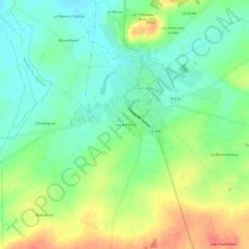
Name: Topografische Karte Les Arènes, Höhe, Relief.
Durchschnittliche Höhe: 151 m
Minimale Höhe: 129 m
Maximale Höhe: 184 m
Andere topografische Karten
Klicken Sie auf eine Karte, um ihre Topografie, ihre Höhe und ihr Relief anzuzeigen.
Saint-Martin-de-Lamps
France > Centre-Val de Loire > Indre > Levroux
Saint-Martin-de-Lamps, Levroux, Châteauroux, Indre, Centre-Val de Loire, France métropolitaine, 36110, France
Durchschnittliche Höhe: 150 m
Levroux
France > Centre-Val de Loire > Indre > Levroux
Levroux, Châteauroux, Indre, Centre-Val de Loire, France métropolitaine, 36110, France
Durchschnittliche Höhe: 161 m