
Topografische Karte Shrewsbury
Interaktive Karte
Klicken Sie auf die Karte, um die Höhe anzuzeigen.
Über diese Karte
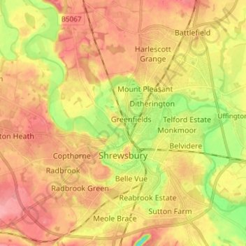
Name: Topografische Karte Shrewsbury, Höhe, Relief.
Ort: Shrewsbury, Shropshire, England, United Kingdom (52.68019 -2.81432 52.75498 -2.70122)
Durchschnittliche Höhe: 69 m
Minimale Höhe: 19 m
Maximale Höhe: 103 m
The town centre is partially built on a hill whose elevation is, at its highest, 246 feet (75 m) above sea level. The longest river in the United Kingdom, the River Severn, flows through the town, forming a meander around its centre. The Rea Brook is a small river that has its confluence with the Severn at Shrewsbury, just upstream from the English Bridge, and much of the Rea Brook Valley within the town is a country park and local nature reserve, encompassing 36 hectares (89 acres). The town is subject to flooding from these rivers.
Andere topografische Karten
Klicken Sie auf eine Karte, um ihre Topografie, ihre Höhe und ihr Relief anzuzeigen.
Snailbeach
United Kingdom > England > Shropshire
Snailbeach, Shropshire, England, SY5 0NX, United Kingdom
Durchschnittliche Höhe: 248 m
Stanton Lacy
United Kingdom > England > Shropshire
Stanton Lacy, Shropshire, England, United Kingdom
Durchschnittliche Höhe: 137 m
Hanwood Bank
United Kingdom > England > Shropshire > Hanwood
Hanwood Bank, Great Hanwood, Hanwood, Shropshire, England, SY5 8NF, United Kingdom
Durchschnittliche Höhe: 92 m
Obley
United Kingdom > England > Shropshire > Clunbury
Obley, Clunbury, Shropshire, England, SY7 0BZ, United Kingdom
Durchschnittliche Höhe: 310 m
Wooton
United Kingdom > England > Shropshire
Wooton, Oswestry Rural, Shropshire, England, SY11 4LH, United Kingdom
Durchschnittliche Höhe: 90 m
Newnes
United Kingdom > England > Shropshire > Ellesmere > Newnes
Newnes, Ellesmere Rural, Ellesmere, Shropshire, West Midlands, England, SY12 9HH, United Kingdom
Durchschnittliche Höhe: 101 m