
Topografische Karte Volcano
Interaktive Karte
Klicken Sie auf die Karte, um die Höhe anzuzeigen.
Volcano
Its altitude ranges from below 2,800 feet (850 m) in the southeast to over 6,200 feet (1,900 m) at its uninhabited northern end. Due to this, Volcano features a subtropical highland climate (Köppen Cfb), with relatively uniform temperatures and abundant rainfall throughout the year, although rainfall is concentrated during the months of November through April.
Über diese Karte
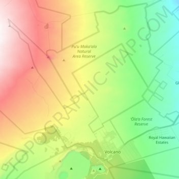
Name: Topografische Karte Volcano, Höhe, Relief.
Ort: Volcano, Hawaiʻi County, Hawaii, United States (19.41769 -155.34518 19.56076 -155.16399)
Durchschnittliche Höhe: 1.219 m
Minimale Höhe: 715 m
Maximale Höhe: 1.959 m