
Topografische Karte Lawn
Interaktive Karte
Klicken Sie auf die Karte, um die Höhe anzuzeigen.
Über diese Karte
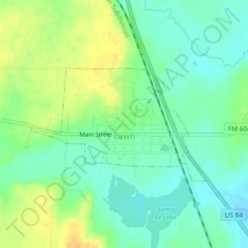
Name: Topografische Karte Lawn, Höhe, Relief.
Ort: Lawn, Taylor County, Texas, United States (32.12994 -99.76183 32.14232 -99.73902)
Durchschnittliche Höhe: 586 m
Minimale Höhe: 574 m
Maximale Höhe: 603 m
Andere topografische Karten
Klicken Sie auf eine Karte, um ihre Topografie, ihre Höhe und ihr Relief anzuzeigen.
Abilene
United States > Texas > Taylor County
Abilene, Taylor County, Texas, United States
Durchschnittliche Höhe: 533 m
Ovalo
United States > Texas > Taylor County
Ovalo, Taylor County, Texas, 79541, United States
Durchschnittliche Höhe: 621 m
Bradshaw
United States > Texas > Taylor County
Bradshaw, Taylor County, Texas, United States
Durchschnittliche Höhe: 603 m
Potosi
United States > Texas > Taylor County
Potosi, Taylor County, Texas, United States
Durchschnittliche Höhe: 562 m
Tuscola
United States > Texas > Taylor County
Tuscola, Taylor County, Texas, United States
Durchschnittliche Höhe: 603 m
Buffalo Gap
United States > Texas > Taylor County
Buffalo Gap, Taylor County, Texas, 79608, United States
Durchschnittliche Höhe: 597 m
Hamby
United States > Texas > Taylor County > Hamby
Hamby, Taylor County, Texas, United States
Durchschnittliche Höhe: 532 m
Tuscola
United States > Texas > Taylor County > Tuscola
Tuscola, Taylor County, Texas, United States
Durchschnittliche Höhe: 603 m