
Topografische Karte Whitesville
Interaktive Karte
Klicken Sie auf die Karte, um die Höhe anzuzeigen.
Über diese Karte
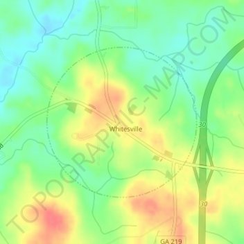
Name: Topografische Karte Whitesville, Höhe, Relief.
Ort: Whitesville, Harris County, Georgia, United States (32.81006 -85.04173 32.82669 -85.02198)
Durchschnittliche Höhe: 208 m
Minimale Höhe: 183 m
Maximale Höhe: 239 m
Andere topografische Karten
Klicken Sie auf eine Karte, um ihre Topografie, ihre Höhe und ihr Relief anzuzeigen.
Pine Mountain
United States > Georgia > Harris County
Pine Mountain, Harris County, Georgia, United States
Durchschnittliche Höhe: 271 m
Shiloh
United States > Georgia > Harris County
Shiloh, Harris County, Georgia, United States
Durchschnittliche Höhe: 264 m
Antioch
United States > Georgia > Harris County
Antioch, Harris County, Georgia, United States
Durchschnittliche Höhe: 175 m
Mountain Hill
United States > Georgia > Harris County
Mountain Hill, Harris County, Georgia, United States
Durchschnittliche Höhe: 219 m
Hamilton
United States > Georgia > Harris County
Hamilton, Harris County, Georgia, United States
Durchschnittliche Höhe: 247 m
Ossahatchie
United States > Georgia > Harris County
Ossahatchie, Harris County, Georgia, 31807, United States
Durchschnittliche Höhe: 202 m
Mulberry Grove
United States > Georgia > Harris County
Mulberry Grove, Harris County, Georgia, United States
Durchschnittliche Höhe: 184 m
Hopewell
United States > Georgia > Harris County
Hopewell, Harris County, Georgia, United States
Durchschnittliche Höhe: 244 m
Ellerslie
United States > Georgia > Harris County
Ellerslie, Harris County, Georgia, 31807, United States
Durchschnittliche Höhe: 208 m
Cataula
United States > Georgia > Harris County
Cataula, Harris County, Georgia, 31804, United States
Durchschnittliche Höhe: 197 m
Waverly Hall
United States > Georgia > Harris County
Waverly Hall, Harris County, Georgia, 31831, United States
Durchschnittliche Höhe: 217 m
Ridgeway
United States > Georgia > Harris County
Ridgeway, Harris County, Georgia, 31831, United States
Durchschnittliche Höhe: 206 m
Jones Crossroads
United States > Georgia > Harris County
Jones Crossroads, Harris County, Georgia, United States
Durchschnittliche Höhe: 229 m
Pine Mountain Valley
United States > Georgia > Harris County
Pine Mountain Valley, Harris County, Georgia, 31823, United States
Durchschnittliche Höhe: 256 m
Pine Mountain
United States > Georgia > Harris County
Pine Mountain, Harris County, Georgia, United States
Durchschnittliche Höhe: 274 m
Piney Grove
United States > Georgia > Harris County
Piney Grove, Harris County, Georgia, 31808, United States
Durchschnittliche Höhe: 166 m