
Topografische Karte Anzac
Klicken Sie auf die Karte, um die Höhe anzuzeigen.
Über diese Karte
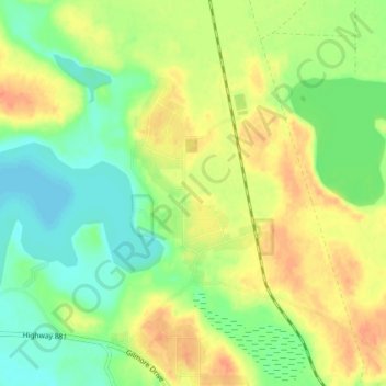
Name: Topografische Karte Anzac, Höhe, Relief.
Ort: Anzac, Wood Buffalo, Alberta, T0P 1J0, Canada (56.43259 -111.06824 56.47259 -111.02824)
Durchschnittliche Höhe: 491 m
Minimale Höhe: 471 m
Maximale Höhe: 513 m
Andere topografische Karten
Klicken Sie auf eine Karte, um ihre Topografie, ihre Höhe und ihr Relief anzuzeigen.
Fort McMurray
Canada > Alberta > Wood Buffalo
The community lies at a lower elevation than most other parts of Alberta, so under the right conditions it can be a "hot spot" for Alberta.
Durchschnittliche Höhe: 345 m
Fort McKay
Canada > Alberta > Wood Buffalo
Fort McKay (/məˈkaɪ/ mə-KY) or Fort MacKay is a community in northeast Alberta, Canada that is located at the confluence of the Athabasca and MacKay rivers. It is approximately 54 km (34 mi) north of Fort McMurray via Highway 63 and Fort McKay Road. The community has an elevation of 260 m (850 ft).
Durchschnittliche Höhe: 259 m
Fort McMurray
Canada > Alberta > Wood Buffalo
The community lies at a lower elevation than most other parts of Alberta, so under the right conditions it can be a "hot spot" for Alberta.
Durchschnittliche Höhe: 346 m
Fort McKay
Canada > Alberta > Wood Buffalo
Fort McKay (/məˈkaɪ/ mə-KY) or Fort MacKay is a community in northeast Alberta, Canada, located at the confluence of the Athabasca and MacKay rivers. It is approximately 54 km (34 mi) north of Fort McMurray via Highway 63 and Fort McKay Road. The community has an elevation of 260 m (850 ft).
Durchschnittliche Höhe: 259 m