Geolokalisieren
👉 Easily get elevation data in JSON, GeoTIFF and KML formats using Elevation API
Vielen Dank für die Unterstützung dieser Website ❤️
Spenden

Rüsten Sie sich für Ihr nächstes Abenteuer:

Als Amazon-Partner erhält diese Website eine Provision für qualifizierte Käufe, ohne zusätzliche Kosten für Sie.

Topografische Karte Singtam

Klicken Sie auf die Karte, um die Höhe anzuzeigen.

Singtam

Singtam is located at 27°09′N 88°23′E / 27.15°N 88.38°E / 27.15; 88.38. It has an average elevation of 1396 feet. As the town lies on the bank of two rivers River Teesta and Ranikhola, so during Monsoon especially from June to September the volume of both the river increases heavily, as a result destruction is caused on the low lying areas of the town especially at Adarsh gaon and Jublee line part of the town.

Wikipedia (CC-BY-SA 3.0)

👉 Easily get elevation data in JSON, GeoTIFF and KML formats using Elevation API
Vielen Dank für die Unterstützung dieser Website ❤️
Spenden

Über diese Karte

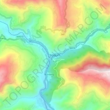
Name: Topografische Karte Singtam, Höhe, Relief.

Ort: Singtam, Gangtok, Sikkim, 737134, India (27.19200 88.45708 27.27200 88.53708)

Durchschnittliche Höhe: 894 m

Minimale Höhe: 302 m

Maximale Höhe: 1.889 m

👉 Easily get elevation data in JSON, GeoTIFF and KML formats using Elevation API
Vielen Dank für die Unterstützung dieser Website ❤️
Spenden

Andere topografische Karten

Klicken Sie auf eine Karte, um ihre Topografie, ihre Höhe und ihr Relief anzuzeigen.

Upper Sichey

India > Sikkim

Durchschnittliche Höhe: 1.459 m

East Sikkim District

India > Sikkim

Durchschnittliche Höhe: 2.107 m

Mangan

India > Sikkim

Mangan is the largest of the six districts of Sikkim. The landscape is mountainous with dense vegetation all the way up to the alpine altitude before thinning out to desert scrub towards the northern tundra. Numerous waterfalls astride the main road make the trip to this district extremely picturesque.

Durchschnittliche Höhe: 4.407 m

Namchi

India > Sikkim

Namchi district lies at an altitude of 400 to 2000 metres and has a temperate climate for most of the year. Major urban centres include Namchi, Ravangla, Jorethang and Melli.

Durchschnittliche Höhe: 1.775 m

West Sikkim District

India > Sikkim

West Sikkim (now officially named as Geyzing District) is a district of the Indian state of Sikkim. Its headquarter is Geyzing, also known as Gyalshing. The district is a favourite with trekkers due to the high elevations. Other important towns include Pelling and Yuksom. Local people also call it as…

Durchschnittliche Höhe: 2.686 m

Pakyong subdivision

India > Sikkim

Durchschnittliche Höhe: 1.527 m

Gyalshing

India > Sikkim

Durchschnittliche Höhe: 3.139 m

Gangtok district

India > Sikkim

Durchschnittliche Höhe: 2.334 m

Vielen Dank für die Unterstützung dieser Website ❤️
Spenden

Rüsten Sie sich für Ihr nächstes Abenteuer:

Als Amazon-Partner erhält diese Website eine Provision für qualifizierte Käufe, ohne zusätzliche Kosten für Sie.

Chungthang

India > Sikkim

Durchschnittliche Höhe: 4.598 m

Soreng

India > Sikkim

Durchschnittliche Höhe: 1.612 m

Tadong Ward

India > Sikkim

Durchschnittliche Höhe: 1.154 m

Pakyong

India > Sikkim

Durchschnittliche Höhe: 1.789 m

Gangtok subdivision

India > Sikkim

Durchschnittliche Höhe: 2.334 m

Goecha La Lake

India > Sikkim > Mangan

Durchschnittliche Höhe: 4.953 m

Barsey Rhododendron WLS

India > Sikkim > Soreng > Singling

Durchschnittliche Höhe: 2.115 m

Lower Sichey

India > Sikkim > Gangtok

Durchschnittliche Höhe: 1.352 m

Vielen Dank für die Unterstützung dieser Website ❤️
Spenden

South Lhonak Glacier

India > Sikkim > Chungthang

Durchschnittliche Höhe: 5.830 m

Rabongla Buddha Park

India > Sikkim > Ravong > Ravangla

Durchschnittliche Höhe: 1.947 m

Central Park

India > Sikkim > Namchi > Namchi

Durchschnittliche Höhe: 1.296 m

Changgu

India > Sikkim > Gangtok subdivision

Durchschnittliche Höhe: 3.876 m

Vielen Dank für die Unterstützung dieser Website ❤️
Spenden

Rüsten Sie sich für Ihr nächstes Abenteuer:

Als Amazon-Partner erhält diese Website eine Provision für qualifizierte Käufe, ohne zusätzliche Kosten für Sie.

Lachung Chu

India > Sikkim > Chungthang > Lachung

Durchschnittliche Höhe: 4.332 m

Namchi

India > Sikkim

Namchi district lies at an altitude of 400 to 2000 metres and has a temperate climate for most of the year. Major urban centres include Namchi, Ravangla, Jorethang and Melli.

Durchschnittliche Höhe: 1.775 m

Mangan

India > Sikkim

Mangan is the largest of the six districts of Sikkim. The landscape is mountainous with dense vegetation all the way up to the alpine altitude before thinning out to desert scrub towards the northern tundra. Numerous waterfalls astride the main road make the trip to this district extremely picturesque.

Durchschnittliche Höhe: 4.407 m

Soreng

India > Sikkim

Durchschnittliche Höhe: 1.612 m

Zemu Chu

India > Sikkim > Chungthang

Durchschnittliche Höhe: 3.657 m

Pakyong

India > Sikkim

Durchschnittliche Höhe: 1.789 m

Zemu Glacier

India > Sikkim > Chungthang

Durchschnittliche Höhe: 5.510 m

Rüsten Sie sich für Ihr nächstes Abenteuer:

📷Wildkameras - Beobachtung der heimischen Fauna im eigenen Revier
🔭Nachtsichtgeräte - Beobachtung der Natur nach Sonnenuntergang
🧼Biologische Outdoor-Seife - Umweltfreundliche Hygiene für unterwegs
🧭Digitaler Kompass & GPS - Hightech‑Navigationsgerät fürs Gelände
🩹Erste-Hilfe-Sets Outdoor - Kompakte Notfallversorgung für Wanderer

Als Amazon-Partner erhält diese Website eine Provision für qualifizierte Käufe, ohne zusätzliche Kosten für Sie.