
Topografische Karte Bishop Sutton
Klicken Sie auf die Karte, um die Höhe anzuzeigen.
Über diese Karte
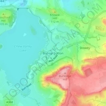
Name: Topografische Karte Bishop Sutton, Höhe, Relief.
Durchschnittliche Höhe: 86 m
Minimale Höhe: 46 m
Maximale Höhe: 175 m
Andere topografische Karten
Klicken Sie auf eine Karte, um ihre Topografie, ihre Höhe und ihr Relief anzuzeigen.
Bath
United Kingdom > England > Bath and North East Somerset
Bath is in the Avon Valley and is surrounded by limestone hills as it is near the southern edge of the Cotswolds, a designated Area of Outstanding Natural Beauty, and the limestone Mendip Hills rise around 7 miles (11 km) south of the city. The hills that surround and make up the city have a maximum altitude…
Durchschnittliche Höhe: 100 m
Chew Valley Lake
United Kingdom > England > Bath and North East Somerset > Compton Martin
Durchschnittliche Höhe: 67 m
Charlcombe
United Kingdom > England > Bath and North East Somerset
The local geology of the Swainswick valley around Sopers Wood, in the south Cotswolds, has been investigated because of the presence of landslides since the work of William Smith in 1799. These are caused by the over-steepened topography downslope of the cap rock formed by the Great Oolite where water egresses…
Durchschnittliche Höhe: 131 m
River Chew
United Kingdom > England > Bath and North East Somerset > Compton Dando
Durchschnittliche Höhe: 76 m
Saltford
United Kingdom > England > Bath and North East Somerset > Saltford
Durchschnittliche Höhe: 42 m
Peasedown St. John
United Kingdom > England > Bath and North East Somerset
Durchschnittliche Höhe: 125 m
Hinton Charterhouse
United Kingdom > England > Bath and North East Somerset
Durchschnittliche Höhe: 94 m
Sydney Gardens
United Kingdom > England > Bath and North East Somerset > Bath
Durchschnittliche Höhe: 75 m
Keynsham Memorial Park
United Kingdom > England > Bath and North East Somerset > Keynsham
Durchschnittliche Höhe: 29 m
Clutton
United Kingdom > England > Bath and North East Somerset > Clutton
Durchschnittliche Höhe: 139 m
Farrington Gurney
United Kingdom > England > Bath and North East Somerset
Durchschnittliche Höhe: 118 m
Norton Malreward
United Kingdom > England > Bath and North East Somerset
Durchschnittliche Höhe: 104 m
Nempnett Thrubwell
United Kingdom > England > Bath and North East Somerset
Durchschnittliche Höhe: 111 m
Sydney Gardens
United Kingdom > England > Bath and North East Somerset > Bath
Durchschnittliche Höhe: 77 m
Bath
United Kingdom > England > Bath and North East Somerset
The floodplain of the Avon has an altitude of about 59 ft (18 m) above sea level, although the city centre is at an elevation of around 25 metres (82 ft) above sea level. The river, once an unnavigable series of braided streams broken up by swamps and ponds, has been managed by weirs into a single channel.…
Durchschnittliche Höhe: 100 m
Bath
United Kingdom > England > Bath and North East Somerset
Bath is in the Avon Valley and is surrounded by limestone hills as it is near the southern edge of the Cotswolds, a designated Area of Outstanding Natural Beauty, and the Mendip Hills rise around 7 miles (11 km) south of the city. The hills that surround and make up the city have a maximum altitude of 781 feet…
Durchschnittliche Höhe: 100 m
Bath
United Kingdom > England > Bath and North East Somerset
Bath is in the Avon Valley and is surrounded by limestone hills as it is near the southern edge of the Cotswolds, a designated Area of Outstanding Natural Beauty, and the limestone Mendip Hills rise around 7 miles (11 km) south of the city. The hills that surround and make up the city have a maximum altitude…
Durchschnittliche Höhe: 100 m
Bath
United Kingdom > England > Bath and North East Somerset
Bath is in the Avon Valley and is surrounded by limestone hills as it is near the southern edge of the Cotswolds, a designated Area of Outstanding Natural Beauty, and the Mendip Hills rise around 7 miles (11 km) south of the city. The hills that surround and make up the city have a maximum altitude of 781 feet…
Durchschnittliche Höhe: 100 m
Bath
United Kingdom > England > Bath and North East Somerset
Bath is in the Avon Valley and is surrounded by limestone hills as it is near the southern edge of the Cotswolds, a designated Area of Outstanding Natural Beauty, and the Mendip Hills rise around 7 miles (11 km) south of the city. The hills that surround and make up the city have a maximum altitude of 781 feet…
Durchschnittliche Höhe: 100 m