
Topografische Karte Ghatkesar
Interaktive Karte
Klicken Sie auf die Karte, um die Höhe anzuzeigen.
Über diese Karte
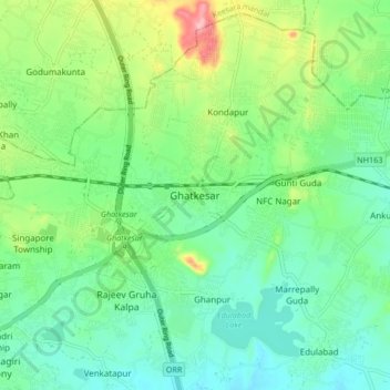
Name: Topografische Karte Ghatkesar, Höhe, Relief.
Durchschnittliche Höhe: 482 m
Minimale Höhe: 439 m
Maximale Höhe: 585 m
Andere topografische Karten
Klicken Sie auf eine Karte, um ihre Topografie, ihre Höhe und ihr Relief anzuzeigen.
Edulabad
India > Telangana > Ghatkesar mandal
Edulabad, Ghatkesar mandal, Medchal–Malkajgiri District, Telangana, India
Durchschnittliche Höhe: 454 m
Subprabhat Colony
India > Telangana > Ghatkesar mandal
Subprabhat Colony, Ghatkesar mandal, Medchal–Malkajgiri, Telangana, 501301, India
Durchschnittliche Höhe: 475 m
Korremula
India > Telangana > Ghatkesar mandal
Korremula, Ghatkesar mandal, Medchal–Malkajgiri, Telangana, India
Durchschnittliche Höhe: 455 m
Ankushapur
India > Telangana > Ghatkesar mandal > Ankushapur
Ankushapur, Ghatkesar mandal, Medchal–Malkajgiri, Telangana, 500088, India
Durchschnittliche Höhe: 463 m
Narepally
India > Telangana > Ghatkesar mandal > Narepally
Narepally, Ghatkesar mandal, Medchal–Malkajgiri, Telangana, 500098, India
Durchschnittliche Höhe: 486 m