
Topografische Karte Kirkton
Interaktive Karte
Klicken Sie auf die Karte, um die Höhe anzuzeigen.
Über diese Karte
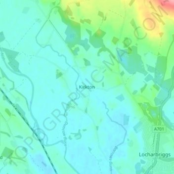
Name: Topografische Karte Kirkton, Höhe, Relief.
Durchschnittliche Höhe: 24 m
Minimale Höhe: 7 m
Maximale Höhe: 102 m
Andere topografische Karten
Klicken Sie auf eine Karte, um ihre Topografie, ihre Höhe und ihr Relief anzuzeigen.
Newton
United Kingdom > Scotland > Dumfries and Galloway
Newton, Dumfries and Galloway, Scotland, DG10 9NX, United Kingdom
Durchschnittliche Höhe: 117 m
Beattock
United Kingdom > Scotland > Dumfries and Galloway
Beattock, Dumfries and Galloway, Scotland, DG10 9RB, United Kingdom
Durchschnittliche Höhe: 144 m
Calfield
United Kingdom > Scotland > Dumfries and Galloway > Langholm > Becks
Calfield, Becks, Langholm, Dumfries and Galloway, Scotland, DG13 0LP, United Kingdom
Durchschnittliche Höhe: 204 m
Closeburn
United Kingdom > Scotland > Dumfries and Galloway
Closeburn, Dumfries and Galloway, Scotland, DG3 5HT, United Kingdom
Durchschnittliche Höhe: 81 m