
Spenden
Rüsten Sie sich für Ihr nächstes Abenteuer:
Als Amazon-Partner erhält diese Website eine Provision für qualifizierte Käufe, ohne zusätzliche Kosten für Sie.
Topografische Karte Elephant Rocks
Klicken Sie auf die Karte, um die Höhe anzuzeigen.
Spenden
Rüsten Sie sich für Ihr nächstes Abenteuer:
Als Amazon-Partner erhält diese Website eine Provision für qualifizierte Käufe, ohne zusätzliche Kosten für Sie.
Über diese Karte
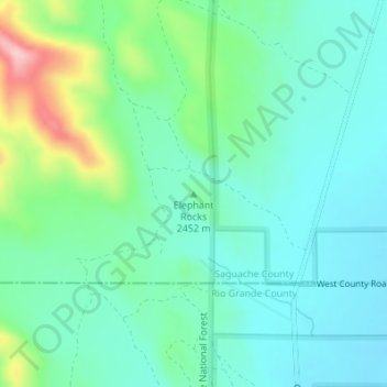
Name: Topografische Karte Elephant Rocks, Höhe, Relief.
Ort: Elephant Rocks, Saguache County, Colorado, United States (37.75440 -106.31619 37.75450 -106.31609)
Durchschnittliche Höhe: 2.448 m
Minimale Höhe: 2.393 m
Maximale Höhe: 2.619 m
Spenden
Rüsten Sie sich für Ihr nächstes Abenteuer:
Als Amazon-Partner erhält diese Website eine Provision für qualifizierte Käufe, ohne zusätzliche Kosten für Sie.
Andere topografische Karten
Klicken Sie auf eine Karte, um ihre Topografie, ihre Höhe und ihr Relief anzuzeigen.
Great Sand Dunes National Park
United States > Colorado > Saguache County
In 1848, John C. Frémont was hired to find a railroad route from St. Louis to California. He crossed the Sangre de Cristos into the San Luis Valley in winter, courting disaster but proving that a winter crossing of this range was possible. He was followed in 1853 by Captain John Gunnison of the Corps of…
Durchschnittliche Höhe: 2.616 m
Spenden
Rüsten Sie sich für Ihr nächstes Abenteuer:
Als Amazon-Partner erhält diese Website eine Provision für qualifizierte Käufe, ohne zusätzliche Kosten für Sie.
Great Sand Dunes National Preserve
United States > Colorado > Saguache County
In 1848, John C. Frémont was hired to find a railroad route from St. Louis to California. He crossed the Sangre de Cristos into the San Luis Valley in winter, courting disaster but proving that a winter crossing of this range was possible. He was followed in 1853 by Captain John Gunnison of the Corps of…
Durchschnittliche Höhe: 2.792 m
Great Sand Dunes National Park
United States > Colorado > Saguache County
In 1848, John C. Frémont was hired to find a railroad route from St. Louis to California. He crossed the Sangre de Cristos into the San Luis Valley in winter, courting disaster but proving that a winter crossing of this range was possible. He was followed in 1853 by Captain John Gunnison of the Corps of…
Durchschnittliche Höhe: 2.616 m