
Topografische Karte Dolpa
Interaktive Karte
Klicken Sie auf die Karte, um die Höhe anzuzeigen.
Dolpa
Dolpa is the largest district of Nepal covering 5.36% of the total landmass of the country. It is located at 28°43’N to 29°43’N latitude and 82°23’E to 83°41’E longitude. Elevation ranges from 1,525 to 7,625 m (5,003 to 25,016 ft). The district borders Tibet on the north and northeast, Jumla and Mugu districts on the west, Myagdi, Jajarkot, Western and Eastern Rukum on the south, and Mustang on the east.
Über diese Karte
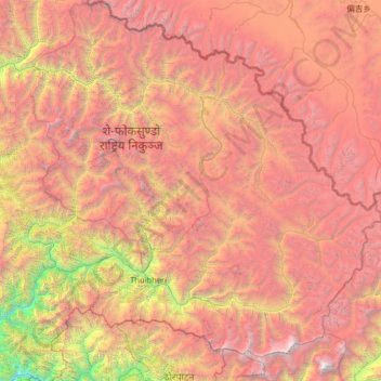
Name: Topografische Karte Dolpa, Höhe, Relief.
Ort: Dolpa, Karnali Province, Nepal (28.72190 82.39256 29.70741 83.67995)
Durchschnittliche Höhe: 4.555 m
Minimale Höhe: 972 m
Maximale Höhe: 8.065 m
Andere topografische Karten
Klicken Sie auf eine Karte, um ihre Topografie, ihre Höhe und ihr Relief anzuzeigen.