
Topografische Karte Sabrosa
Interaktive Karte
Klicken Sie auf die Karte, um die Höhe anzuzeigen.
Über diese Karte
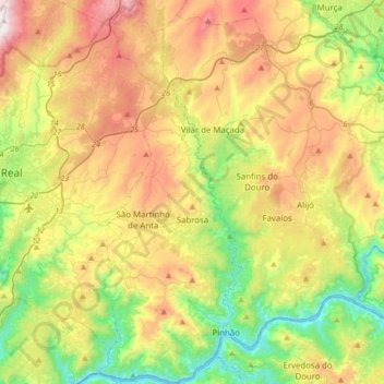
Name: Topografische Karte Sabrosa, Höhe, Relief.
Ort: Sabrosa, Vila Real, Portugal (41.15612 -7.65817 41.41255 -7.53150)
Durchschnittliche Höhe: 565 m
Minimale Höhe: 72 m
Maximale Höhe: 1.282 m
Andere topografische Karten
Klicken Sie auf eine Karte, um ihre Topografie, ihre Höhe und ihr Relief anzuzeigen.
Vidago (União das freguesias de Vidago, Arcossó, Selhariz e Vilarinho das Paranheiras)
Durchschnittliche Höhe: 444 m