
Spenden
Rüsten Sie sich für Ihr nächstes Abenteuer:
Als Amazon-Partner erhält diese Website eine Provision für qualifizierte Käufe, ohne zusätzliche Kosten für Sie.
Topografische Karte Distrito Ciudad de Tunuyán
Klicken Sie auf die Karte, um die Höhe anzuzeigen.
Spenden
Rüsten Sie sich für Ihr nächstes Abenteuer:
Als Amazon-Partner erhält diese Website eine Provision für qualifizierte Käufe, ohne zusätzliche Kosten für Sie.
Distrito Ciudad de Tunuyán
Tunuyán is a city in the west of the province of Mendoza, Argentina, located on the western shore of the Tunuyán River, 80 km (50 mi) south from the provincial capital Mendoza and 100 km (62 mi) east of the Chilean border. It has 49,132 inhabitants, and is the head town of the Tunuyán Department. Along with the Tupungato Department and the San Carlos Department it makes up the "Valle de Uco" region, which is famous in the Argentine wine industry for its important and modern vineyards and wineries. Investments since the millennium, attracted by the climate, soil, and altitude combination, have transformed the area, making it one of Argentina's most important regions when it comes to high-quality wine production and its associated connoisseur-driven enotourism.
Spenden
Rüsten Sie sich für Ihr nächstes Abenteuer:
Als Amazon-Partner erhält diese Website eine Provision für qualifizierte Käufe, ohne zusätzliche Kosten für Sie.
Über diese Karte
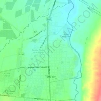
Name: Topografische Karte Distrito Ciudad de Tunuyán, Höhe, Relief.
Durchschnittliche Höhe: 877 m
Minimale Höhe: 854 m
Maximale Höhe: 930 m
Spenden
Rüsten Sie sich für Ihr nächstes Abenteuer:
Als Amazon-Partner erhält diese Website eine Provision für qualifizierte Käufe, ohne zusätzliche Kosten für Sie.
Andere topografische Karten
Klicken Sie auf eine Karte, um ihre Topografie, ihre Höhe und ihr Relief anzuzeigen.
Cerro El Plata
Argentina > Mendoza > Distrito La Carrera
Cerro El Plata is the highest peak of the Cordón del Plata which is a subrange of the Andes. The mountain is located 65 kilometres (40 miles) southeast of Aconcagua and 60 kilometres (37 miles) west of the provincial capital, the city of Mendoza. Precipitation runoff from the mountains drains into the Mendoza…
Durchschnittliche Höhe: 5.374 m
Andes
Argentina > Mendoza > Distrito Las Cuevas
The Andes Mountains are the highest mountain range outside Asia. The highest mountain outside Asia, Argentina's Mount Aconcagua, rises to an elevation of about 6,961 m (22,838 ft) above sea level. The peak of Chimborazo in the Ecuadorian Andes is farther from the Earth's center than any other location on the…
Durchschnittliche Höhe: 6.208 m
Spenden
Rüsten Sie sich für Ihr nächstes Abenteuer:
Als Amazon-Partner erhält diese Website eine Provision für qualifizierte Käufe, ohne zusätzliche Kosten für Sie.
San Rafael
Argentina > Mendoza > Distrito Ciudad de San Rafael > San Rafael
Durchschnittliche Höhe: 690 m
Luján de Cuyo
Argentina > Mendoza > Departamento Luján de Cuyo > Luján de Cuyo
Durchschnittliche Höhe: 951 m