
Topografische Karte Temoaya
Interaktive Karte
Klicken Sie auf die Karte, um die Höhe anzuzeigen.
Über diese Karte
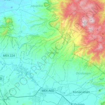
Name: Topografische Karte Temoaya, Höhe, Relief.
Ort: Temoaya, Mexico, 50850, Mexico (19.39625 -99.73111 19.58238 -99.48927)
Durchschnittliche Höhe: 2.790 m
Minimale Höhe: 2.533 m
Maximale Höhe: 3.767 m
The climate is temperate and relatively humid with rains mostly in the summer. Average temperature is 13.4C, ranging between 9 and 35.5C. It is one of the coldest municipalities in the Toluca Valley due to its altitude. Frosts can occur between October and April and morning fog is not uncommon the rest of the year. In the higher elevations there are forest with pine, cedar, oyamel and other trees. In the lower areas there are some broadleaf trees but there are more areas with grass and shrub. Most of the flat areas are cultivated with both field crops and orchards. Very little wildlife remains due to the degradation of most of the ecosystem here. Some small mammals such as squirrels, rabbits and the like remain as well as some bird species. Aquatic life has completely disappeared from the Lerma River area.
Andere topografische Karten
Klicken Sie auf eine Karte, um ihre Topografie, ihre Höhe und ihr Relief anzuzeigen.
Tejupilco de Hidalgo
Mexico > Mexico > Tejupilco de Hidalgo
Tejupilco de Hidalgo, Tejupilco, Mexico, 51400, Mexico
Durchschnittliche Höhe: 1.501 m
San Pablo de las Salinas
Mexico > Mexico > San Pablo de las Salinas
San Pablo de las Salinas, Tultitlán, Mexico, 549131, Mexico
Durchschnittliche Höhe: 2.245 m
San Buenaventura
Mexico > Mexico > San Buenaventura
San Buenaventura, Ixtapaluca, Mexico, 56643, Mexico
Durchschnittliche Höhe: 2.285 m
Ixtapaluca
Mexico > Mexico > Ixtapaluca
Ixtapaluca, Mexico, 56535, Mexico
Durchschnittliche Höhe: 2.440 m
Chimalhuacán
Mexico > Mexico > Chimalhuacán
Chimalhuacán, Mexico, 56334, Mexico
Durchschnittliche Höhe: 2.304 m
Santa Cruz Atizapán.
Mexico > Mexico > Santa Cruz Atizapán.
Santa Cruz Atizapán., Atizapán, Mexico, 52640, Mexico
Durchschnittliche Höhe: 2.602 m
Presa Brockman
Mexico > Mexico > Presa Brockman
Presa Brockman, El Oro, Mexico
Durchschnittliche Höhe: 2.947 m
El Oro de Hidalgo
Mexico > Mexico > El Oro de Hidalgo
El Oro de Hidalgo, El Oro, Mexico
Durchschnittliche Höhe: 2.809 m
Nevado de Toluca
Nevado de Toluca, Toluca, Mexico
Durchschnittliche Höhe: 4.230 m