
Topografische Karte Jahazpur
Interaktive Karte
Klicken Sie auf die Karte, um die Höhe anzuzeigen.
Über diese Karte
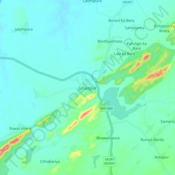
Name: Topografische Karte Jahazpur, Höhe, Relief.
Ort: Jahazpur, Jahazpur Tehsil, Bhilwara, Rajasthan, 305409, India (25.57847 75.23711 25.65847 75.31711)
Durchschnittliche Höhe: 350 m
Minimale Höhe: 318 m
Maximale Höhe: 514 m
Jahazpur is located at 25°37′N 75°17′E / 25.62°N 75.28°E / 25.62; 75.28. It has an average elevation of 334 m (1,096 ft). There is a Jain Mandir in the shape of a Jahaz (ship) being built there popularized as Atishay Kshetra dedicated to Bhagwan Munisuvrata Nath.The under construction temple is on the Jahazpur-Shahpura (Bhilwara) State Highway No. 39 which is around 24 km from Deoli,a town in the Tonk District of Rajasthan on the National Highway running from Jabalpur to Jaipur.