
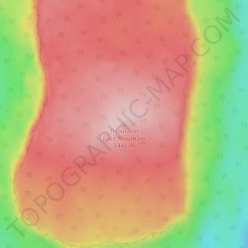
Topografische Karte Thousand Lake Mountain
Interaktive Karte
Klicken Sie auf die Karte, um die Höhe anzuzeigen.
Über diese Karte
Name: Topografische Karte Thousand Lake Mountain, Höhe, Relief.
Ort: Thousand Lake Mountain, Wayne County, Utah, USA (38.41695 -111.47926 38.41705 -111.47916)
Durchschnittliche Höhe: 3.341 m
Minimale Höhe: 3.167 m
Maximale Höhe: 3.443 m
Andere topografische Karten
Klicken Sie auf eine Karte, um ihre Topografie, ihre Höhe und ihr Relief anzuzeigen.
Canyonlands National Park - Maze District
Canyonlands National Park - Maze District, White Rim Road, San Juan County, Utah, USA
Durchschnittliche Höhe: 1.546 m
Great Salt Lake
Great Salt Lake, Box Elder County, Utah, USA
Durchschnittliche Höhe: 1.380 m
Long Valley Junction
USA > Utah > Long Valley Junction
Long Valley Junction, Kane County, Utah, 84710, USA
Durchschnittliche Höhe: 2.295 m
Haystack Lake
Haystack Lake, Lakes Country Trail, Summit County, Utah, USA
Durchschnittliche Höhe: 3.067 m
Capitol Hill
USA > Utah > Salt Lake City
Capitol Hill, Salt Lake City, Salt Lake County, Utah, 84103, USA
Durchschnittliche Höhe: 1.510 m
La Sal Mountains Viewpoint
La Sal Mountains Viewpoint, Arches Entrance Road, Grand County, Utah, 84532-2134, USA
Durchschnittliche Höhe: 1.347 m
Browns Park
Browns Park, Bountiful, Davis County, Utah, 84010, USA
Durchschnittliche Höhe: 1.556 m
Timpanogos Glacier
USA > Utah > Aspen Grove
Timpanogos Glacier, Mount Timpanogos Trail #052, Aspen Grove, Utah County, Utah, USA
Durchschnittliche Höhe: 3.148 m
Gladys Lake
Gladys Lake, Head of Rock Creek Trail, Duchesne County, Utah, USA
Durchschnittliche Höhe: 3.385 m
Little Bear River
Little Bear River, Cache County, Utah, 84319, USA
Durchschnittliche Höhe: 1.475 m
San Juan River
San Juan River, San Juan County, Utah, 84717, USA
Durchschnittliche Höhe: 1.967 m