
Topografische Karte Frederiksted
Interaktive Karte
Klicken Sie auf die Karte, um die Höhe anzuzeigen.
Über diese Karte
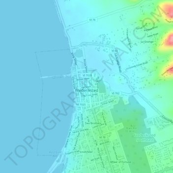
Name: Topografische Karte Frederiksted, Höhe, Relief.
Durchschnittliche Höhe: 14 m
Minimale Höhe: -2 m
Maximale Höhe: 110 m
Rainforests are located on this western side of St. Croix due to the topography and 1,400 foot peaks and the tradewinds. This rainforest climate is unique to the Frederiksted side of St. Croix.
Andere topografische Karten
Klicken Sie auf eine Karte, um ihre Topografie, ihre Höhe und ihr Relief anzuzeigen.
Saint Croix
United States > United States Virgin Islands > Saint Croix District > Christiansted
Saint Croix, Christiansted, Saint Croix District, United States Virgin Islands, United States
Durchschnittliche Höhe: 11 m
Longford (Anna's Hope Village)
United States > United States Virgin Islands > Saint Croix District
Longford (Anna's Hope Village), Saint Croix District, United States Virgin Islands, 00824, United States
Durchschnittliche Höhe: 49 m
Cartlon South
United States > United States Virgin Islands > Saint Croix District > Cartlon South
Cartlon South, Saint Croix District, United States Virgin Islands, 00840, United States
Durchschnittliche Höhe: 23 m
Morningstar
United States > United States Virgin Islands > Saint Croix District > Morningstar
Morningstar, Saint Croix District, United States Virgin Islands, 00820, United States
Durchschnittliche Höhe: 68 m
Virgin Islands
United States > United States Virgin Islands > Saint Croix District
Virgin Islands, Saint Croix District, United States Virgin Islands, United States
Durchschnittliche Höhe: 2 m