
Topografische Karte Olentangy River
Interaktive Karte
Klicken Sie auf die Karte, um die Höhe anzuzeigen.
Über diese Karte
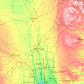
Name: Topografische Karte Olentangy River, Höhe, Relief.
Durchschnittliche Höhe: 314 m
Minimale Höhe: 218 m
Maximale Höhe: 460 m
Andere topografische Karten
Klicken Sie auf eine Karte, um ihre Topografie, ihre Höhe und ihr Relief anzuzeigen.
Maumee River
Maumee River, Oregon, Lucas County, Ohio, 43434, USA
Durchschnittliche Höhe: 178 m
Ohio River
USA > Ohio > Cincinnati
Ohio River, East Pete Rose Way, Lytle Park Historic District, Mount Adams, Cincinnati, Hamilton County, Ohio, 45202, USA
Durchschnittliche Höhe: 177 m
Mount Adams
USA > Ohio > Cincinnati
Mount Adams, Cincinnati, Hamilton County, Ohio, 45202, USA
Durchschnittliche Höhe: 181 m
Wayne National Forest
Wayne National Forest, Old Forrest Ridge Road, Waterloo, Lawrence County, Ohio, 45688, USA
Durchschnittliche Höhe: 252 m
Cuyahoga River
USA > Ohio > Brecksville
Cuyahoga River, Brecksville, Sagamore Hills Township, Summit County, Ohio, 44264, USA
Durchschnittliche Höhe: 273 m
Clermont County
Ohio Township, Clermont County, Ohio, 45157, USA
Durchschnittliche Höhe: 219 m
Lake Alma State Park
Lake Alma State Park, Puritan, Clinton Township, Vinton County, Ohio, 45634, USA
Durchschnittliche Höhe: 232 m
Clifton
USA > Ohio > Cincinnati
Clifton, Cincinnati, Hamilton County, Ohio, USA
Durchschnittliche Höhe: 194 m
Hueston Woods
USA > Ohio > Morning Sun
Hueston Woods, West Shore Trail, Morning Sun, Preble County, Ohio, 45003, USA
Durchschnittliche Höhe: 289 m
Bainbridge
USA > Ohio > Bainbridge
Bainbridge, Bainbridge Township, Geauga County, Ohio, 44023, USA
Durchschnittliche Höhe: 340 m
Continental
USA > Ohio > Continental
Continental, Putnam County, Ohio, 45831, USA
Durchschnittliche Höhe: 220 m
Woodland Mound
Woodland Mound, 8250, Eightmile, Hamilton County, Ohio, 45255, USA
Durchschnittliche Höhe: 203 m
The Heights
USA > Ohio > Cincinnati
The Heights, Cincinnati, Hamilton County, Ohio, USA
Durchschnittliche Höhe: 220 m
Big Darby Creek
Big Darby Creek, Brown Township, Madison County, Ohio, USA
Durchschnittliche Höhe: 278 m
Earls Island
USA > Ohio > Earls Island
Earls Island, Shelby County, Ohio, 45865, USA
Durchschnittliche Höhe: 294 m
Epworth Heights
USA > Ohio > Epworth Heights
Epworth Heights, Miami Township, Clermont County, Ohio, 45140, USA
Durchschnittliche Höhe: 217 m
Day Heights
USA > Ohio > Day Heights
Day Heights, Miami Township, Clermont County, Ohio, 45150, USA
Durchschnittliche Höhe: 257 m
Middletown Dam
USA > Ohio > Middletown
Middletown Dam, Middletown, Warren County, Ohio, 45042, USA
Durchschnittliche Höhe: 207 m
Russell Center
USA > Ohio > Russell Center
Russell Center, Russell Township, Geauga County, Ohio, 44072, USA
Durchschnittliche Höhe: 338 m
Corryville
USA > Ohio > Cincinnati
Corryville, Cincinnati, Hamilton County, Ohio, USA
Durchschnittliche Höhe: 237 m
Wildwood Preserve Metropark
USA > Ohio > Central Avenue Park
Wildwood Preserve Metropark, Central Avenue Park, Lucas County, Ohio, USA
Durchschnittliche Höhe: 196 m
Filson Park
USA > Ohio > Cincinnati
Filson Park, Prospect Hill Historic District, Prospect Hill, Cincinnati, Hamilton County, Ohio, USA
Durchschnittliche Höhe: 206 m
Moxahala Creek
Moxahala Creek, Muskingum County, Ohio, 43734, USA
Durchschnittliche Höhe: 247 m
Charles Mill Lake
USA > Ohio > Mifflin Cottage Area
Charles Mill Lake, Schiago Trail, Mifflin Cottage Area, Mifflin Township, Ashland County, Ohio, 44805, USA
Durchschnittliche Höhe: 332 m
Cowan Lake
Cowan Lake, State Park Drive, Cuba, Clinton County, Ohio, 45114, USA
Durchschnittliche Höhe: 306 m
Blanchard River
Blanchard River, Putnam County, Ohio, 45875, USA
Durchschnittliche Höhe: 223 m
Wingfoot Lake
USA > Ohio > Suffield Station
Wingfoot Lake, Goodyear Park Boulevard, Suffield Station, Suffield Township, Portage County, Ohio, 44260, USA
Durchschnittliche Höhe: 354 m
Mentor Marsh State Nature Preserve
Mentor Marsh State Nature Preserve, Corduroy Road, Mentor, Lake County, Ohio, 44060, USA
Durchschnittliche Höhe: 183 m
Kokosing River
Kokosing River, Morris Township, Knox County, Ohio, 43050, USA
Durchschnittliche Höhe: 360 m
Metro Parks, Serving Summit County - Offices
Metro Parks, Serving Summit County - Offices, 975, Waters Edge, Merriman Valley, Akron, Summit County, Ohio, 44313, USA
Durchschnittliche Höhe: 271 m
Shade River
USA > Ohio > Shade River
Shade River, Meigs County, Ohio, 45743, USA
Durchschnittliche Höhe: 213 m
Maumee Bay
Maumee Bay, Lilias Drive, Oregon, Lucas County, Ohio, 43618, USA
Durchschnittliche Höhe: 172 m
Prattsville
USA > Ohio > Prattsville
Prattsville, Madison Township, Vinton County, Ohio, 45698, USA
Durchschnittliche Höhe: 259 m
South Shore Park
USA > Ohio > South Shore Park
South Shore Park, Lucas County, Ohio, 43618, USA
Durchschnittliche Höhe: 176 m
Goll Woods
Goll Woods, County Road G, Elmira, Fulton County, Ohio, 43502:43570, USA
Durchschnittliche Höhe: 219 m
Shanersville
USA > Ohio > Shanersville
Shanersville, Montgomery County, Ohio, 45449, USA
Durchschnittliche Höhe: 284 m
Stage's Pond State Nature Preserve
Stage's Pond State Nature Preserve, Ward Road, Walnut Township, Pickaway County, Ohio, 43103, USA
Durchschnittliche Höhe: 218 m
Mohican River
Mohican River, Monroe Township, Richland County, Ohio, 44904, USA
Durchschnittliche Höhe: 354 m