
Topografische Karte Anne Arundel County
Interaktive Karte
Klicken Sie auf die Karte, um die Höhe anzuzeigen.
Über diese Karte
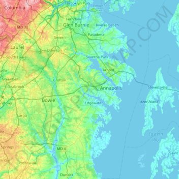
Name: Topografische Karte Anne Arundel County, Höhe, Relief.
Ort: Anne Arundel County, Maryland, United States (38.70925 -76.84033 39.23711 -76.34858)
Durchschnittliche Höhe: 25 m
Minimale Höhe: -3 m
Maximale Höhe: 161 m
Elevations in Anne Arundel County range from sea level at the Chesapeake and tidal tributaries to about 300 feet (91 m) in western areas near the fall line. The terrain is mostly flat or gently rolling, but more dramatic banks and bluffs can be found where waterways cut through areas of higher elevation.
Andere topografische Karten
Klicken Sie auf eine Karte, um ihre Topografie, ihre Höhe und ihr Relief anzuzeigen.
Gambrills
United States > Maryland > Anne Arundel County > Gambrills
Gambrills, Anne Arundel County, Maryland, United States
Durchschnittliche Höhe: 37 m
Lake Bernard Frank
United States > Maryland > Montgomery County
Lake Bernard Frank, Montgomery County, Maryland, United States
Durchschnittliche Höhe: 114 m
Rockville
United States > Maryland > Montgomery County
Rockville, Montgomery County, Maryland, United States
Durchschnittliche Höhe: 122 m
Chesapeake Forest - Aughty Naughty Complex
United States > Maryland > Wicomico County
Chesapeake Forest - Aughty Naughty Complex, Wicomico County, Maryland, United States
Durchschnittliche Höhe: 9 m
Gravely
United States > Maryland > Anne Arundel County
Gravely, Anne Arundel County, Maryland, 21035, United States
Durchschnittliche Höhe: 35 m
Mayo
United States > Maryland > Anne Arundel County
Mayo, Anne Arundel County, Maryland, 21106, United States
Durchschnittliche Höhe: 2 m
McHenry
United States > Maryland > Garrett County
McHenry, Garrett County, Maryland, 21541, United States
Durchschnittliche Höhe: 817 m
Silver Spring
United States > Maryland > Montgomery County > Silver Spring
Silver Spring, Montgomery County, Maryland, United States
Durchschnittliche Höhe: 86 m
Dundalk
United States > Maryland > Baltimore County > Dundalk
Dundalk, Baltimore County, Maryland, 21222, United States
Durchschnittliche Höhe: 6 m
Mays Chapel
United States > Maryland > Baltimore County > Mays Chapel
Mays Chapel, Baltimore County, Maryland, 21093, United States
Durchschnittliche Höhe: 129 m
Middle East
United States > Maryland > Baltimore
Middle East, Baltimore, Maryland, United States
Durchschnittliche Höhe: 29 m
Fort Meade
United States > Maryland > Anne Arundel County > Fort Meade
Fort Meade, Anne Arundel County, Maryland, United States
Durchschnittliche Höhe: 53 m
Saint Mary's County
Saint Mary's County, Maryland, United States
Durchschnittliche Höhe: 13 m
Oldtown
United States > Maryland > Oldtown
Oldtown, Allegany County, Maryland, 26722, United States
Durchschnittliche Höhe: 194 m
Croom
United States > Maryland > Prince George's County > Croom
Croom, Prince George's County, Maryland, United States
Durchschnittliche Höhe: 47 m
Baltimore County
Baltimore County, Maryland, United States
Durchschnittliche Höhe: 123 m