
Topografische Karte Coal Valley
Interaktive Karte
Klicken Sie auf die Karte, um die Höhe anzuzeigen.
Über diese Karte
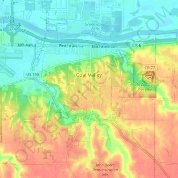
Name: Topografische Karte Coal Valley, Höhe, Relief.
Durchschnittliche Höhe: 198 m
Minimale Höhe: 170 m
Maximale Höhe: 230 m
Andere topografische Karten
Klicken Sie auf eine Karte, um ihre Topografie, ihre Höhe und ihr Relief anzuzeigen.
Carbon Cliff
United States > Illinois > Rock Island County
Carbon Cliff, Rock Island County, Illinois, 61239, United States
Durchschnittliche Höhe: 188 m
Port Byron
United States > Illinois > Rock Island County
Port Byron, Rock Island County, Illinois, United States
Durchschnittliche Höhe: 202 m
Rapids City
United States > Illinois > Rock Island County
Rapids City, Rock Island County, Illinois, 61278, United States
Durchschnittliche Höhe: 196 m
Moline
United States > Illinois > Rock Island County
Moline, Rock Island County, Illinois, 61265, United States
Durchschnittliche Höhe: 193 m
Milan
United States > Illinois > Rock Island County
Milan, Rock Island County, Illinois, 61624, United States
Durchschnittliche Höhe: 192 m
Moline
United States > Illinois > Rock Island County > Moline
Moline, Rock Island County, Illinois, 61265, United States
Durchschnittliche Höhe: 210 m
Andalusia
United States > Illinois > Rock Island County > Andalusia
Andalusia, Rock Island County, Illinois, 61232, United States
Durchschnittliche Höhe: 186 m
East Moline
United States > Illinois > Rock Island County
East Moline, Rock Island County, Illinois, United States
Durchschnittliche Höhe: 191 m
Oak Grove
United States > Illinois > Rock Island County
Oak Grove, Rock Island County, Illinois, United States
Durchschnittliche Höhe: 217 m