
Topografische Karte Victoria Bryant State Park
Interaktive Karte
Klicken Sie auf die Karte, um die Höhe anzuzeigen.
Über diese Karte
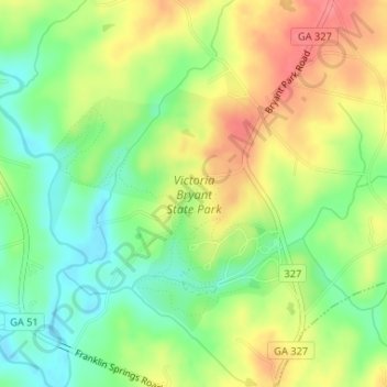
Name: Topografische Karte Victoria Bryant State Park, Höhe, Relief.
Durchschnittliche Höhe: 211 m
Minimale Höhe: 175 m
Maximale Höhe: 253 m
Andere topografische Karten
Klicken Sie auf eine Karte, um ihre Topografie, ihre Höhe und ihr Relief anzuzeigen.
Carnesville
United States > Georgia > Franklin County
Carnesville, Franklin County, Georgia, United States
Durchschnittliche Höhe: 223 m
Gumlog
United States > Georgia > Franklin County
Gumlog, Franklin County, Georgia, United States
Durchschnittliche Höhe: 230 m
Franklin Springs
United States > Georgia > Franklin County
Franklin Springs, Franklin County, Georgia, 30639, United States
Durchschnittliche Höhe: 236 m
Sandy Cross
United States > Georgia > Franklin County
Sandy Cross, Franklin County, Georgia, United States
Durchschnittliche Höhe: 235 m
Lavonia
United States > Georgia > Franklin County
Lavonia, Franklin County, Georgia, 30553, United States
Durchschnittliche Höhe: 249 m
Lavonia
United States > Georgia > Franklin County > Lavonia > Lavonia
Lavonia, Franklin County, Georgia, 20553, United States
Durchschnittliche Höhe: 247 m
Canon
United States > Georgia > Franklin County
Canon, Franklin County, Georgia, United States
Durchschnittliche Höhe: 268 m
Royston
United States > Georgia > Franklin County
Royston, Franklin County, Georgia, United States
Durchschnittliche Höhe: 259 m