Geolokalisieren

Topografische Karte Croissant Kergoz

Interaktive Karte

Klicken Sie auf die Karte, um die Höhe anzuzeigen.

Über diese Karte

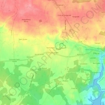
Name: Topografische Karte Croissant Kergoz, Höhe, Relief.

Ort: Croissant Kergoz, Nizon, Pont-Aven, Quimper, Finistère, Bretagne, France métropolitaine, 29930, France (47.83734 -3.79573 47.87734 -3.75573)

Durchschnittliche Höhe: 52 m

Minimale Höhe: 0 m

Maximale Höhe: 94 m

Andere topografische Karten

Klicken Sie auf eine Karte, um ihre Topografie, ihre Höhe und ihr Relief anzuzeigen.

Roz An Bidou

France > Bretagne > Finistère > Nizon

Roz An Bidou, Nizon, Pont-Aven, Quimper, Finistère, Bretagne, France métropolitaine, 29930, France

Durchschnittliche Höhe: 48 m

Kergazuel

France > Bretagne > Finistère > Nizon

Kergazuel, Nizon, Pont-Aven, Quimper, Finistère, Bretagne, France métropolitaine, 29930, France

Durchschnittliche Höhe: 74 m

Kergam

France > Bretagne > Finistère > Nizon

Kergam, Nizon, Pont-Aven, Quimper, Finistère, Bretagne, France métropolitaine, 29930, France

Durchschnittliche Höhe: 50 m

Rue de la Villemarqué

France > Bretagne > Finistère > Nizon > Kergam

Rue de la Villemarqué, Rue Émile Bernard, Keranna, Kergam, Nizon, Pont-Aven, Quimper, Finistère, Bretagne, France métropolitaine, 29930, France

Durchschnittliche Höhe: 49 m

Kergoz

France > Bretagne > Finistère > Nizon

Kergoz, Nizon, Pont-Aven, Quimper, Finistère, Bretagne, France métropolitaine, 29930, France

Durchschnittliche Höhe: 54 m