
Topografische Karte Scarborough
Interaktive Karte
Klicken Sie auf die Karte, um die Höhe anzuzeigen.
Über diese Karte
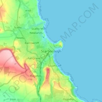
Name: Topografische Karte Scarborough, Höhe, Relief.
Durchschnittliche Höhe: 39 m
Minimale Höhe: -1 m
Maximale Höhe: 184 m
The climate is temperate with mild summers and cool, windy, winters. The hottest months of the year are July and August, with temperatures reaching an average high of 17 °C and falling to 11 °C at night. The average daytime temperatures in January are 4 °C, falling to 1 °C at night. The station's elevation of 110 m (360 ft) is far above sea level compared to the immediate coastline, where the climate is likely slightly milder year round.
Andere topografische Karten
Klicken Sie auf eine Karte, um ihre Topografie, ihre Höhe und ihr Relief anzuzeigen.
Rathmell
United Kingdom > England > North Yorkshire
Rathmell, North Yorkshire, England, BD24 0FG, United Kingdom
Durchschnittliche Höhe: 172 m
Osgodby
United Kingdom > England > North Yorkshire
Osgodby, North Yorkshire, England, YO11 3PT, United Kingdom
Durchschnittliche Höhe: 43 m
Esk Valley
United Kingdom > England > North Yorkshire > Scarborough > Grosmont
Esk Valley, Grosmont, Scarborough, North Yorkshire, England, YO22 5BG, United Kingdom
Durchschnittliche Höhe: 127 m
Whitby
United Kingdom > England > North Yorkshire
Whitby, Scarborough, North Yorkshire, England, United Kingdom
Durchschnittliche Höhe: 37 m
Selby
United Kingdom > England > North Yorkshire > Selby
Selby, North Yorkshire, England, United Kingdom
Durchschnittliche Höhe: 7 m