
Topografische Karte Abraham Lake
Interaktive Karte
Klicken Sie auf die Karte, um die Höhe anzuzeigen.
Über diese Karte
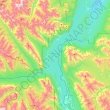
Name: Topografische Karte Abraham Lake, Höhe, Relief.
Ort: Abraham Lake, Census Division No. 9, Alberta, Canada (52.07360 -116.48898 52.33277 -116.32587)
Durchschnittliche Höhe: 1.886 m
Minimale Höhe: 1.222 m
Maximale Höhe: 3.095 m
The Government of Alberta sponsored a contest to name the lake in February 1972, during the final stages of construction of the Bighorn Dam. Students across the province were asked to submit names taking into consideration "historical significance, prominent persons, geography and topography, and the value of the lake." It was eventually named after Silas Abraham (c. 1870–1964), of the Stoney Nakoda First Nation and originally from Morley, Alberta. He was a farmer and hunter who lived in the Kootenay Plains and later on the Big Horn 144A reserve.
Andere topografische Karten
Klicken Sie auf eine Karte, um ihre Topografie, ihre Höhe und ihr Relief anzuzeigen.
Moutain Vew Park
Canada > Alberta > Census Division No. 9 > Rocky Mountain House
Moutain Vew Park, Rocky Mountain House, Census Division No. 9, Alberta, Canada
Durchschnittliche Höhe: 978 m