
Spenden
Rüsten Sie sich für Ihr nächstes Abenteuer:
Als Amazon-Partner erhält diese Website eine Provision für qualifizierte Käufe, ohne zusätzliche Kosten für Sie.
Topografische Karte Taylor Peak
Klicken Sie auf die Karte, um die Höhe anzuzeigen.
Spenden
Rüsten Sie sich für Ihr nächstes Abenteuer:
Als Amazon-Partner erhält diese Website eine Provision für qualifizierte Käufe, ohne zusätzliche Kosten für Sie.
Über diese Karte
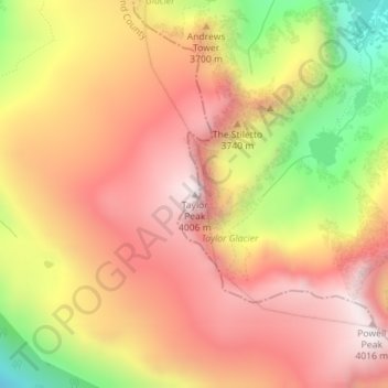
Name: Topografische Karte Taylor Peak, Höhe, Relief.
Ort: Taylor Peak, Grand County, Colorado, United States (40.27473 -105.68090 40.27483 -105.68080)
Durchschnittliche Höhe: 3.646 m
Minimale Höhe: 3.072 m
Maximale Höhe: 4.015 m
Spenden
Rüsten Sie sich für Ihr nächstes Abenteuer:
Als Amazon-Partner erhält diese Website eine Provision für qualifizierte Käufe, ohne zusätzliche Kosten für Sie.
Andere topografische Karten
Klicken Sie auf eine Karte, um ihre Topografie, ihre Höhe und ihr Relief anzuzeigen.
Grand Lake
United States > Colorado > Grand County
Established in 1881, Grand Lake sits at an elevation of 8,369 feet (2,551 m) and derives its name from the lake on whose shores it is situated: Grand Lake, the largest natural body of water in Colorado. The town of Grand Lake was originally an outfitting and supply point for the mining settlements of Lulu…
Durchschnittliche Höhe: 2.630 m
Winter Park
United States > Colorado > Grand County
Its elevation ranges from approximately 8,700 to 12,060 feet (2,650 to 3,680 m) above sea level, and is considered sub-alpine country. It is snow-covered for about six months a year. Although the town center is at about 9,000 feet (2,700 m) above sea level, Winter Park, using administrative boundaries as a…
Durchschnittliche Höhe: 3.061 m
Tabernash
United States > Colorado > Grand County > Tabernash
On August 10, 1984, a Cessna L-19 Bird Dog (registration N4584A), piloted by James Jeb Caddell, 36, crashed in a forest near Tabernash. The aircraft was en route from Granby to Jeffco Airport, Colorado. Despite the efforts of a search party, the two men could not be located, as the plane had flipped over and…
Durchschnittliche Höhe: 2.593 m
Spenden
Rüsten Sie sich für Ihr nächstes Abenteuer:
Als Amazon-Partner erhält diese Website eine Provision für qualifizierte Käufe, ohne zusätzliche Kosten für Sie.
Winter Park
United States > Colorado > Grand County
Its elevation ranges from approximately 8,700 to 12,060 feet (2,650 to 3,680 m) above sea level, and is considered sub-alpine country. It is snow-covered for about six months a year. Although the town center is at about 9,000 feet (2,700 m) above sea level, Winter Park, using administrative boundaries as a…
Durchschnittliche Höhe: 3.061 m
Spenden
Rüsten Sie sich für Ihr nächstes Abenteuer:
Als Amazon-Partner erhält diese Website eine Provision für qualifizierte Käufe, ohne zusätzliche Kosten für Sie.
Grand Lake
United States > Colorado > Grand County
Established in 1881, Grand Lake sits at an elevation of 8,369 feet (2,551 m) and derives its name from the lake on whose shores it is situated: Grand Lake, the largest natural body of water in Colorado. The town of Grand Lake was originally an outfitting and supply point for the mining settlements of Lulu…
Durchschnittliche Höhe: 2.630 m
Spenden
Rüsten Sie sich für Ihr nächstes Abenteuer:
Als Amazon-Partner erhält diese Website eine Provision für qualifizierte Käufe, ohne zusätzliche Kosten für Sie.
Winter Park Resort
United States > Colorado > Grand County > Winter Park
Durchschnittliche Höhe: 3.089 m
Tabernash
United States > Colorado > Grand County > Tabernash
On August 10, 1984, a Cessna L-19 Bird Dog (registration N4584A), piloted by James Jeb Caddell, 36, crashed in a forest near Tabernash. The aircraft was en route from Granby to Jeffco Airport, Colorado. The wreckage was found by backpackers three years later on August 23, 1987. A 6½ minute video shot from a…
Durchschnittliche Höhe: 2.593 m
Spenden
Rüsten Sie sich für Ihr nächstes Abenteuer:
Als Amazon-Partner erhält diese Website eine Provision für qualifizierte Käufe, ohne zusätzliche Kosten für Sie.
Fraser
United States > Colorado > Grand County
Fraser is located in southeastern Grand County at 39°56′39″N 105°48′48″W / 39.94417°N 105.81333°W / 39.94417; -105.81333 (39.944158, -105.813355), at an elevation of 8,574 feet (2,613 m) above sea level. It is bordered to the south by the town of Winter Park and to the north by…
Durchschnittliche Höhe: 2.696 m