
Topografische Karte Khangchendzonga National Park
Interaktive Karte
Klicken Sie auf die Karte, um die Höhe anzuzeigen.
Über diese Karte
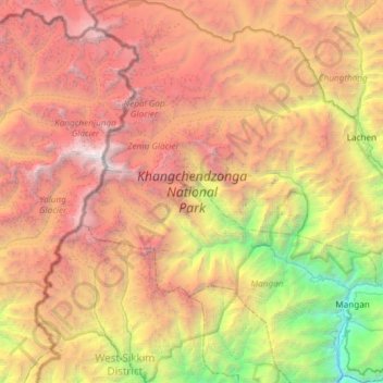
Name: Topografische Karte Khangchendzonga National Park, Höhe, Relief.
Durchschnittliche Höhe: 4.330 m
Minimale Höhe: 599 m
Maximale Höhe: 8.521 m
The Kanchenjunga Park is situated in the North and West Sikkim districts in the Indian state of Sikkim. It has an elevation of 1,829 metres (6,001 ft) to over 8,550 metres (28,050 ft) and has an area of 849.50 km2 (327.99 sq mi). It is one of the few high-altitude National parks of India and was recently included as a mixed-criteria UNESCO World Heritage site.
Andere topografische Karten
Klicken Sie auf eine Karte, um ihre Topografie, ihre Höhe und ihr Relief anzuzeigen.
East Sikkim District
India > Sikkim > Pakyong subdivision
East Sikkim District, Pakyong subdivision, Pakyong district, Sikkim, India
Durchschnittliche Höhe: 2.107 m
West District
West District, West Sikkim District, Sikkim, 737111, India
Durchschnittliche Höhe: 2.636 m
Lachung
India > Sikkim > Chungthang
Lachung, Chungthang, Mangan District, Sikkim, India
Durchschnittliche Höhe: 3.617 m
East District
India > Sikkim > East District
East District, East Sikkim District, Sikkim, India
Durchschnittliche Höhe: 2.740 m
Zemu Glacier
Zemu Glacier, North District, North Sikkim District, Sikkim, India
Durchschnittliche Höhe: 5.499 m
South District
South District, South Sikkim District, Sikkim, India
Durchschnittliche Höhe: 2.676 m
North District
North District, North Sikkim District, Sikkim, India
Durchschnittliche Höhe: 3.760 m