
Spenden
Rüsten Sie sich für Ihr nächstes Abenteuer:
Als Amazon-Partner erhält diese Website eine Provision für qualifizierte Käufe, ohne zusätzliche Kosten für Sie.
Topografische Karte Pinetop-Lakeside
Klicken Sie auf die Karte, um die Höhe anzuzeigen.
Spenden
Rüsten Sie sich für Ihr nächstes Abenteuer:
Als Amazon-Partner erhält diese Website eine Provision für qualifizierte Käufe, ohne zusätzliche Kosten für Sie.
Über diese Karte
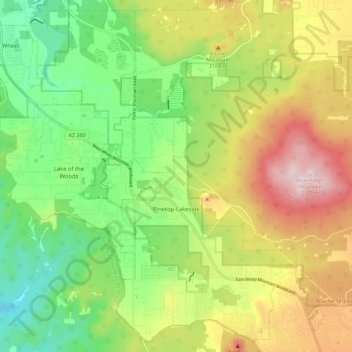
Name: Topografische Karte Pinetop-Lakeside, Höhe, Relief.
Durchschnittliche Höhe: 2.101 m
Minimale Höhe: 1.935 m
Maximale Höhe: 2.331 m
Spenden
Rüsten Sie sich für Ihr nächstes Abenteuer:
Als Amazon-Partner erhält diese Website eine Provision für qualifizierte Käufe, ohne zusätzliche Kosten für Sie.
Andere topografische Karten
Klicken Sie auf eine Karte, um ihre Topografie, ihre Höhe und ihr Relief anzuzeigen.
Monument Valley
United States > Arizona > Navajo County
The area is part of the Colorado Plateau. The elevation of the valley floor ranges from 5,000 to 6,000 feet (1,500 to 1,800 m) above sea level. The floor is largely siltstone of the Cutler Group, or sand derived from it, deposited by the meandering rivers that carved the valley. The valley's vivid red color…
Durchschnittliche Höhe: 1.675 m
Spenden
Rüsten Sie sich für Ihr nächstes Abenteuer:
Als Amazon-Partner erhält diese Website eine Provision für qualifizierte Käufe, ohne zusätzliche Kosten für Sie.
Spenden
Rüsten Sie sich für Ihr nächstes Abenteuer:
Als Amazon-Partner erhält diese Website eine Provision für qualifizierte Käufe, ohne zusätzliche Kosten für Sie.
Heber-Overgaard
United States > Arizona > Navajo County
Heber-Overgaard is a census-designated place (CDP) in Navajo County, Arizona, United States. Situated atop the Mogollon Rim, the community lies at an elevation of 6,627 feet (2,020 m). The population was 2,898 at the 2020 census. Heber and Overgaard are technically two unincorporated communities, but as of the…
Durchschnittliche Höhe: 2.015 m
Spenden
Rüsten Sie sich für Ihr nächstes Abenteuer:
Als Amazon-Partner erhält diese Website eine Provision für qualifizierte Käufe, ohne zusätzliche Kosten für Sie.
Spenden
Rüsten Sie sich für Ihr nächstes Abenteuer:
Als Amazon-Partner erhält diese Website eine Provision für qualifizierte Käufe, ohne zusätzliche Kosten für Sie.
Monument Valley
United States > Arizona > Navajo County
Monument Valley is part of the Colorado Plateau. The elevation of the valley floor ranges from 5,000 to 6,000 feet (1,500 to 1,800 m) above sea level. The floor is largely siltstone of the Cutler Group, or sand derived from it, deposited by the meandering rivers that carved the valley. The valley's vivid red…
Durchschnittliche Höhe: 1.675 m
Three Sisters
United States > Arizona > Navajo County
Monument Valley is part of the Colorado Plateau. The elevation of the valley floor ranges from 5,000 to 6,000 feet (1,500 to 1,800 m) above sea level. The floor is largely siltstone of the Cutler Group, or sand derived from it, deposited by the meandering rivers that carved the valley. The valley's vivid red…
Durchschnittliche Höhe: 1.664 m
West Mitten
United States > Arizona > Navajo County
The Mittens are about 0.6 mi (0.97 km) from the Arizona–Utah state line and West Mitten Butte is 1.1 mi (1.8 km) northeast of the park headquarters. The summit of West Mitten Butte is 6,176 ft (1,882 m) and East Mitten Butte is 6,226 ft (1,898 m) in elevation. The Mittens form a triangle with Merrick Butte…
Durchschnittliche Höhe: 1.616 m
Spenden
Rüsten Sie sich für Ihr nächstes Abenteuer:
Als Amazon-Partner erhält diese Website eine Provision für qualifizierte Käufe, ohne zusätzliche Kosten für Sie.
Heber-Overgaard
United States > Arizona > Navajo County
Heber-Overgaard is a census-designated place (CDP) in Navajo County, Arizona, United States. Situated atop the Mogollon Rim, the community lies at an elevation of 6,627 feet (2,020 m). The population was 2,898 at the 2020 census. Heber and Overgaard are technically two unincorporated communities, but as of the…
Durchschnittliche Höhe: 2.015 m
Kayenta
United States > Arizona > Navajo County
Kayenta is located at 36°42′43″N 110°15′00″W / 36.71194°N 110.25000°W / 36.71194; -110.25000 (36.7118, -110.2505), at an elevation of 5,700 feet, (1,738 m).
Durchschnittliche Höhe: 1.743 m
Spenden
Rüsten Sie sich für Ihr nächstes Abenteuer:
Als Amazon-Partner erhält diese Website eine Provision für qualifizierte Käufe, ohne zusätzliche Kosten für Sie.
Monument Valley
United States > Arizona > Navajo County
The area is part of the Colorado Plateau. The elevation of the valley floor ranges from 5,000 to 6,000 feet (1,500 to 1,800 m) above sea level. The floor is largely siltstone of the Cutler Group, or sand derived from it, deposited by the meandering rivers that carved the valley. The valley's vivid red color…
Durchschnittliche Höhe: 1.675 m
Three Sisters
United States > Arizona > Navajo County
Monument Valley is part of the Colorado Plateau. The elevation of the valley floor ranges from 5,000 to 6,000 feet (1,500 to 1,800 m) above sea level. The floor is largely siltstone of the Cutler Group, or sand derived from it, deposited by the meandering rivers that carved the valley. The valley's vivid red…
Durchschnittliche Höhe: 1.664 m
Spenden
Rüsten Sie sich für Ihr nächstes Abenteuer:
Als Amazon-Partner erhält diese Website eine Provision für qualifizierte Käufe, ohne zusätzliche Kosten für Sie.
Three Sisters
United States > Arizona > Navajo County
The area is part of the Colorado Plateau. The elevation of the valley floor ranges from 5,000 to 6,000 feet (1,500 to 1,800 m) above sea level. The floor is largely siltstone of the Cutler Group, or sand derived from it, deposited by the meandering rivers that carved the valley. The valley's vivid red color…
Durchschnittliche Höhe: 1.664 m
Spenden
Rüsten Sie sich für Ihr nächstes Abenteuer:
Als Amazon-Partner erhält diese Website eine Provision für qualifizierte Käufe, ohne zusätzliche Kosten für Sie.
Marsh Pass
United States > Arizona > Navajo County > Tsegi
Marsh Pass, also known as La Puerta Limita, "The Border Gate", is a gap in Navajo County, Arizona. It lies at an elevation of 6,102 feet (1,860 meters) along Laguña Creek. The name of Marsh Pass is thought to come from its location along a chain of swamps and lakes in the pass, that have since been drained by…
Durchschnittliche Höhe: 1.961 m
Monument Valley
United States > Arizona > Navajo County
The area is part of the Colorado Plateau. The elevation of the valley floor ranges from 5,000 to 6,000 feet (1,500 to 1,800 m) above sea level. The floor is largely siltstone of the Cutler Group, or sand derived from it, deposited by the meandering rivers that carved the valley. The valley's vivid red color…
Durchschnittliche Höhe: 1.675 m