
Topografische Karte Cave City
Interaktive Karte
Klicken Sie auf die Karte, um die Höhe anzuzeigen.
Über diese Karte
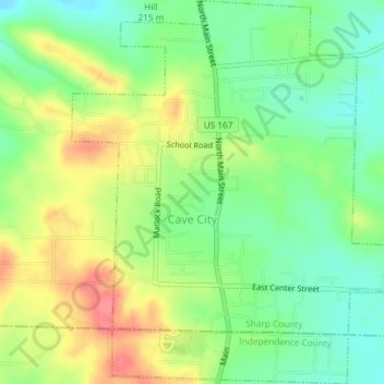
Name: Topografische Karte Cave City, Höhe, Relief.
Ort: Cave City, Sharp County, Arkansas, United States (35.93410 -91.56276 35.96399 -91.52890)
Durchschnittliche Höhe: 205 m
Minimale Höhe: 175 m
Maximale Höhe: 244 m
Andere topografische Karten
Klicken Sie auf eine Karte, um ihre Topografie, ihre Höhe und ihr Relief anzuzeigen.
Williford
United States > Arkansas > Sharp County
Williford, Sharp County, Arkansas, 72482, United States
Durchschnittliche Höhe: 122 m
Ash Flat
United States > Arkansas > Sharp County
Ash Flat, Sharp County, Arkansas, United States
Durchschnittliche Höhe: 191 m
Highland
United States > Arkansas > Sharp County
Highland, Sharp County, Arkansas, United States
Durchschnittliche Höhe: 194 m
Ash Flat Ball Park
United States > Arkansas > Sharp County > Ash Flat
Ash Flat Ball Park, Ash Flat, Sharp County, Arkansas, United States
Durchschnittliche Höhe: 192 m
Cherokee Village
United States > Arkansas > Sharp County > Cherokee Village
Cherokee Village, Sharp County, Arkansas, 72529, United States
Durchschnittliche Höhe: 176 m
Cherokee Village
United States > Arkansas > Sharp County
Cherokee Village, Sharp County, Arkansas, United States
Durchschnittliche Höhe: 177 m
Hardy
United States > Arkansas > Sharp County
Hardy, Sharp County, Arkansas, United States
Durchschnittliche Höhe: 150 m
Evening Shade
United States > Arkansas > Sharp County > Evening Shade
Evening Shade, Sharp County, Arkansas, United States
Durchschnittliche Höhe: 156 m