
Spenden
Rüsten Sie sich für Ihr nächstes Abenteuer:
Als Amazon-Partner erhält diese Website eine Provision für qualifizierte Käufe, ohne zusätzliche Kosten für Sie.
Topografische Karte Dunsmuir
Klicken Sie auf die Karte, um die Höhe anzuzeigen.
Spenden
Rüsten Sie sich für Ihr nächstes Abenteuer:
Als Amazon-Partner erhält diese Website eine Provision für qualifizierte Käufe, ohne zusätzliche Kosten für Sie.
Dunsmuir
At an elevation of approximately 2,350 feet (720 m) above sea level, a unique setting is created by the Sacramento River in which class 3 whitewater rapids are usually created during summer run off through a town of about 2,000 residents. In plain view from some of the city's public streets, this may be one of the few places in western North America where three categories of "twos" (population, elevation, and whitewater difficulty) are met or eclipsed. (Eastern US example-The Cherry River at Richwood, WV)
Spenden
Rüsten Sie sich für Ihr nächstes Abenteuer:
Als Amazon-Partner erhält diese Website eine Provision für qualifizierte Käufe, ohne zusätzliche Kosten für Sie.
Über diese Karte
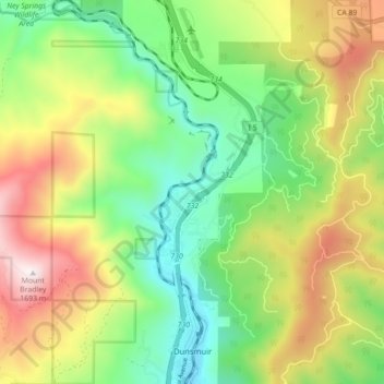
Name: Topografische Karte Dunsmuir, Höhe, Relief.
Durchschnittliche Höhe: 1.075 m
Minimale Höhe: 688 m
Maximale Höhe: 1.674 m
Spenden
Rüsten Sie sich für Ihr nächstes Abenteuer:
Als Amazon-Partner erhält diese Website eine Provision für qualifizierte Käufe, ohne zusätzliche Kosten für Sie.
Andere topografische Karten
Klicken Sie auf eine Karte, um ihre Topografie, ihre Höhe und ihr Relief anzuzeigen.
Mount Shasta
United States > California > Siskiyou County
Mount Shasta (Shasta: Waka-nunee-Tuki-wuki; Karuk: Úytaahkoo) is a potentially active volcano at the southern end of the Cascade Range in Siskiyou County, California. At an elevation of 14,179 feet (4,321.8 meters), it is the second-highest peak in the Cascades and the fifth-highest in the state. Mount Shasta…
Durchschnittliche Höhe: 3.717 m
Spenden
Rüsten Sie sich für Ihr nächstes Abenteuer:
Als Amazon-Partner erhält diese Website eine Provision für qualifizierte Käufe, ohne zusätzliche Kosten für Sie.
Mount Hebron
United States > California > Siskiyou County > Mount Hebron
Durchschnittliche Höhe: 1.299 m
Spenden
Rüsten Sie sich für Ihr nächstes Abenteuer:
Als Amazon-Partner erhält diese Website eine Provision für qualifizierte Käufe, ohne zusätzliche Kosten für Sie.
Dunsmuir
United States > California > Siskiyou County
At an elevation of approximately 2,350 feet (720 m) above sea level, a unique setting is created by the Sacramento River in which class 3 whitewater rapids are usually created during summer run off through a town of about 2,000 residents. In plain view from some of the city's public streets, this may be one of…
Durchschnittliche Höhe: 1.079 m
Spenden
Rüsten Sie sich für Ihr nächstes Abenteuer:
Als Amazon-Partner erhält diese Website eine Provision für qualifizierte Käufe, ohne zusätzliche Kosten für Sie.
Mount Shasta
United States > California > Siskiyou County
Mount Shasta (/ˈʃæstə/ SHASS-tə; Shasta: Waka-nunee-Tuki-wuki; Karuk: Úytaahkoo) is a potentially active volcano at the southern end of the Cascade Range in Siskiyou County, California. At an elevation of 14,179 feet (4,321.8 meters), it is the second-highest peak in the Cascades and the fifth-highest in…
Durchschnittliche Höhe: 3.717 m
Mount Shasta
United States > California > Siskiyou County
Mount Shasta (/ˈʃæstə/ SHASS-tə; Shasta: Waka-nunee-Tuki-wuki; Karuk: Úytaahkoo) is a potentially active stratovolcano at the southern end of the Cascade Range in Siskiyou County, California. At an elevation of 14,179 ft (4,322 m), it is the second-highest peak in the Cascades and the fifth-highest in…
Durchschnittliche Höhe: 3.717 m
Spenden
Rüsten Sie sich für Ihr nächstes Abenteuer:
Als Amazon-Partner erhält diese Website eine Provision für qualifizierte Käufe, ohne zusätzliche Kosten für Sie.
Shastina
United States > California > Siskiyou County
Shastina is a satellite cone of Mount Shasta. It is the second youngest of four overlapping volcanic cones which together form the most voluminous stratovolcano in the Cascade Range. At 12,335 feet (3,760 m), Shastina is taller than Mount Adams and would rank as the third highest volcano in the Cascades behind…
Durchschnittliche Höhe: 3.386 m
Mount Shasta
United States > California > Siskiyou County
Mount Shasta (/ˈʃæstə/ SHASS-tə; Shasta: Waka-nunee-Tuki-wuki; Karuk: Úytaahkoo) is a potentially active stratovolcano at the southern end of the Cascade Range in Siskiyou County, California. At an elevation of 14,179 ft (4,322 m), it is the second-highest peak in the Cascades and the fifth-highest in…
Durchschnittliche Höhe: 3.717 m
Dunsmuir
United States > California > Siskiyou County
At an elevation of approximately 2,350 feet (720 m) above sea level, a unique setting is created by the Sacramento River in which class 3 whitewater rapids are usually created during summer run off through a town of about 2,000 residents. In plain view from some of the city's public streets, this may be one of…
Durchschnittliche Höhe: 1.077 m
Spenden
Rüsten Sie sich für Ihr nächstes Abenteuer:
Als Amazon-Partner erhält diese Website eine Provision für qualifizierte Käufe, ohne zusätzliche Kosten für Sie.
Lava Beds National Monument
United States > California > Siskiyou County
The high elevation, semi-arid desert environment of Lava Beds National Monument receives an average of 14.22 in (36 cm) of annual precipitation, including 43.2 in (110 cm) of snowfall. The climate is characterized by warm, dry summers and cold, moderately snowy winters. The monthly daily average temperature…
Durchschnittliche Höhe: 1.348 m
Spenden
Rüsten Sie sich für Ihr nächstes Abenteuer:
Als Amazon-Partner erhält diese Website eine Provision für qualifizierte Käufe, ohne zusätzliche Kosten für Sie.
Spenden
Rüsten Sie sich für Ihr nächstes Abenteuer:
Als Amazon-Partner erhält diese Website eine Provision für qualifizierte Käufe, ohne zusätzliche Kosten für Sie.
Klamath River
United States > California > Siskiyou County > Klamath River
Durchschnittliche Höhe: 751 m
Spenden
Rüsten Sie sich für Ihr nächstes Abenteuer:
Als Amazon-Partner erhält diese Website eine Provision für qualifizierte Käufe, ohne zusätzliche Kosten für Sie.