
Topografische Karte General Carrera Lake / Lake Buenos Aires
Interaktive Karte
Klicken Sie auf die Karte, um die Höhe anzuzeigen.
Über diese Karte
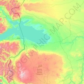
Name: Topografische Karte General Carrera Lake / Lake Buenos Aires, Höhe, Relief.
Durchschnittliche Höhe: 893 m
Minimale Höhe: 152 m
Maximale Höhe: 2.694 m
The lake occupies a continental-scale graben formed by SWS-ENE normal faults that have resulted in down-dropping the bottom of the lake to 350 meters (1,150 ft) below mean sea level. Preservation of younger lithostratigraphic units within the graben form reverse stratigraphy with older units exposed at higher topographic elevations to the south. The graben channeled mountain glaciers which formed terminal moraine helping to modify the present-day shape of the lake. The tectonic activity that formed the depression can be inferred to subduction of the triple joint that has occurred over the past 20 million years, as indicated by ripple marks in volcaniclastic sediments observed along the southern shoreline. There is some speculation on whether the tectonics and crustal heat flow in the lake area are influenced by the asthenospheric window that exists beneath the crust in this region of Patagonia.
Andere topografische Karten
Klicken Sie auf eine Karte, um ihre Topografie, ihre Höhe und ihr Relief anzuzeigen.
Laguna de los tres
Argentina > Santa Cruz Province
Laguna de los tres, Ruta normal al Madsen (F), Lago Argentino, Santa Cruz Province, Argentina
Durchschnittliche Höhe: 1.083 m
Comisión de Fomento de Cañadón Seco
Argentina > Santa Cruz Province
Comisión de Fomento de Cañadón Seco, Deseado, Santa Cruz Province, 9013, Argentina
Durchschnittliche Höhe: 190 m
Lago Nansen
Argentina > Santa Cruz Province
Lago Nansen, Río Chico, Santa Cruz Province, Argentina
Durchschnittliche Höhe: 1.221 m
Calafate
Argentina > Santa Cruz Province > Las Heras
Calafate, Las Heras, Deseado, Santa Cruz Province, Argentina
Durchschnittliche Höhe: 333 m
Laguna Sucia
Argentina > Santa Cruz Province
Laguna Sucia, Lago Argentino, Santa Cruz Province, Argentina
Durchschnittliche Höhe: 1.307 m
Mesa
Argentina > Santa Cruz Province
Mesa, Lago Buenos Aires, Santa Cruz Province, Argentina
Durchschnittliche Höhe: 475 m
Costa del Sol
Argentina > Santa Cruz Province > Atlántico
Costa del Sol, Atlántico, Caleta Olivia, Deseado, Santa Cruz Province, Argentina
Durchschnittliche Höhe: 18 m
Río Turbio
Argentina > Santa Cruz Province
Río Turbio, Güer Aike, Santa Cruz Province, Argentina
Durchschnittliche Höhe: 346 m
El Chaltén
Argentina > Santa Cruz Province
El Chaltén, Lago Argentino, Santa Cruz Province, Argentina
Durchschnittliche Höhe: 513 m
Comandante Luis Piedrabuena
Argentina > Santa Cruz Province
Comandante Luis Piedrabuena, Corpen Aike, Santa Cruz Province, Argentina
Durchschnittliche Höhe: 76 m
Río Gallegos
Argentina > Santa Cruz Province > Río Gallegos
Río Gallegos, Güer Aike, Santa Cruz Province, 9400, Argentina
Durchschnittliche Höhe: 13 m
El Calafate
Argentina > Santa Cruz Province
El Calafate, Lago Argentino, Santa Cruz Province, Argentina
Durchschnittliche Höhe: 250 m
Magallanes
Argentina > Santa Cruz Province
Magallanes, Santa Cruz Province, Argentina
Durchschnittliche Höhe: 244 m
Argentino Lake
Argentina > Santa Cruz Province
Argentino Lake, Lago Argentino, Santa Cruz Province, Argentina
Durchschnittliche Höhe: 687 m
Laguna del Carbón
Argentina > Santa Cruz Province
Laguna del Carbón, Corpen Aike, Santa Cruz Province, Argentina
Durchschnittliche Höhe: -102 m
Ventana
Argentina > Santa Cruz Province
Ventana, Deseado, Santa Cruz Province, Argentina
Durchschnittliche Höhe: 639 m
Río Turbio
Argentina > Santa Cruz Province
Río Turbio, Güer Aike, Santa Cruz Province, Argentina
Durchschnittliche Höhe: 421 m
Las Heras
Argentina > Santa Cruz Province
Las Heras, Deseado, Santa Cruz Province, Argentina
Durchschnittliche Höhe: 328 m